The 10 Best Hikes on Oahu to Conquer in 2026

Oahu is a paradise of dramatic ridges, lush rainforests, and breathtaking coastal cliffs, offering trails for every level of adventurer. Beyond just a walk, these hikes represent personal milestones-stories of endurance and discovery etched into the island's volcanic soul. This guide dives deep into the top 10 hikes on Oahu, providing the critical details you need not just to complete them, but to commemorate them.
This is not just another list of trails. For athletes, runners, and dedicated hikers, every route is a data point, a memory, and a potential work of art. We have curated a comprehensive roundup designed for those who appreciate the metrics as much as the views. We'll cover everything from trail stats and safety tips to unique insights on how to capture your journey.
Inside, you will find a detailed breakdown of each of the island's most iconic routes, including:
- Actionable Data: Precise distance, elevation gain, estimated time, and route difficulty.
- Logistical Details: Access points, parking information, and direct GPS/Strava links.
- Practical Guidance: Key scenic highlights, specific safety notes, and the best times to go.
- Unique Commemoration: We also provide specific suggestions for turning your tracked routes into custom, high-quality RoutePrinter posters, transforming your hard-earned miles into a lasting memory.
Whether you're celebrating a finished marathon with a challenging summit or simply seeking the best views the island has to offer, this guide provides the tools to plan, execute, and remember your adventure. Let's find your next great Oahu hike and make it one for the books-and the walls.
1. Diamond Head Trail (Lēʻahi)
The Diamond Head Trail, or Lēʻahi, is arguably the most famous of all hikes on Oahu. This iconic trek takes you to the summit of a 300,000-year-old volcanic crater, offering unparalleled 360-degree views of Waikiki, the turquoise Pacific Ocean, and Oahu's southeastern coastline. Its accessibility and rewarding payoff make it an essential experience for both visitors and locals.

The trail itself is paved for much of the way, but it climbs steeply through a series of switchbacks and stairs, including a 99-step "stairway to heaven" and a lighted 225-foot tunnel. The hike is short but strenuous, gaining 560 feet in just 0.8 miles to the summit. This consistent, challenging climb makes it a popular route on fitness apps like Strava, with thousands of athletes recording their efforts annually.
Hike Details & Recommendations
- Distance: 1.6 miles (2.6 km) round trip
- Elevation Gain: 560 feet (171 m)
- Time: 1.5 - 2 hours
- Difficulty: Moderate
- Access & Parking: Diamond Head State Monument. An entrance fee and reservations are required for out-of-state visitors. Parking is limited and fills up quickly.
- GPS Route: View on AllTrails
Pro-Tips for an Epic Hike
To maximize your experience, start early. Arriving before 8 AM helps you beat the midday heat and the largest crowds. Bring at least one liter of water per person, as there is little shade. Sturdy walking shoes are recommended over flip-flops due to the uneven surfaces and steep stairs. For those interested in commemorating their achievement, tracking your hike with Strava provides a perfect, accurate route map. This data can be transformed into a stunning piece of art, a unique way to remember one of the best hiking places in the world.
2. Koko Head Trail
Known as one of the most grueling yet rewarding hikes on Oahu, the Koko Head Trail is a true test of physical and mental endurance. This hike is not a traditional trail but a straight ascent up the side of the Koko Crater via 1,048 old railway ties, often called the "Stairs of Doom." The breathtaking 360-degree panoramic views from the summit, showcasing Hanauma Bay and the southeastern coastline, make the intense effort entirely worthwhile.

The steep, relentless climb makes this trail a favorite among fitness enthusiasts and athletes training for everything from marathons to obstacle course races. Conquering Koko Head is a significant achievement, and many hikers use fitness apps to track their climb. The detailed elevation profile captured by a tracker like Strava provides a powerful visual representation of the challenge, perfect for creating a memento. While Koko Head is a dry crater hike, those seeking a different kind of adventure can explore trails with lush scenery, such as the path to Cascade Falls.
Hike Details & Recommendations
- Distance: 1.6 miles (2.6 km) round trip
- Elevation Gain: 990 feet (302 m)
- Time: 1.5 - 2 hours
- Difficulty: Hard
- Access & Parking: Koko Head District Park. Parking is free but can fill up, especially on weekends. There are no entrance fees.
- GPS Route: View on AllTrails
Pro-Tips for an Epic Hike
To conquer Koko Head, go very early in the morning or late in the afternoon to avoid the intense midday sun, as the trail is completely exposed. Bring more water than you think you'll need, at least 2-3 liters per person. Many hikers find gloves helpful for gripping the railway ties on steep sections. Proper hiking shoes with good traction are essential. Capturing your route with a fitness tracker will give you an incredible elevation profile, creating a perfect data set to transform into a custom art print that celebrates this monumental physical accomplishment.
3. Manoa Falls Trail
The Manoa Falls Trail offers a quintessential Hawaiian rainforest experience, guiding hikers through a lush, tropical jungle to the base of a stunning 150-foot waterfall. This well-trodden path immerses you in a world of towering bamboo groves, giant ferns, and native Hawaiian flora, making it one of the most picturesque and accessible hikes on Oahu. Its magical, almost prehistoric atmosphere has made it a filming location for movies like Jurassic Park.
The trail is relatively short but can be challenging due to its often muddy and slippery conditions, a result of the frequent rainfall in the Manoa Valley. The path has been significantly improved with gravel and designated steps, but the terrain remains uneven. This gentle but consistent walk is perfect for families and those looking for a less strenuous adventure, making it a popular choice among our collection of easy hiking trails.
Hike Details & Recommendations
- Distance: 1.6 miles (2.6 km) round trip
- Elevation Gain: 800 feet (243 m)
- Time: 1 - 1.5 hours
- Difficulty: Easy to Moderate
- Access & Parking: Manoa Falls Trailhead. Parking is available for a fee in a designated lot managed by a private company, Paradise Park.
- GPS Route: View on AllTrails
Pro-Tips for an Epic Hike
To make the most of your trek, wear sturdy, waterproof hiking shoes with good grip. The trail is notoriously muddy year-round. Arrive early in the morning to find easier parking and enjoy a more peaceful hike before the midday crowds arrive. Bring insect repellent, as mosquitoes are common in the damp environment. Capturing your journey on Strava provides a beautiful map of your route through the valley, which can be transformed into a unique art piece to commemorate your adventure into Oahu’s verdant interior.
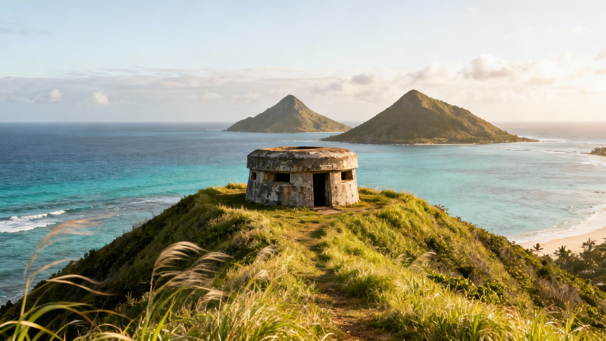
4. Lanikai Pill Box Trail
The Lanikai Pill Box Trail, officially known as the Kaiwa Ridge Trail, is a favorite on the Windward side, offering some of the most spectacular coastal views on the island. This relatively short hike takes you up a scenic ridge to two historic World War II military bunkers, or "pillboxes." The panoramic reward is breathtaking, with sweeping views of the turquoise waters of Lanikai Beach, the iconic Mokulua Islands, and the lush Koʻolau mountain range.

The trail begins with a steep, often slippery, dirt incline that quickly opens up to exposed ridgeline. While the ascent can be challenging, the path is well-trodden and leads to two distinct pillboxes, both perfect spots for a photo opportunity. This hike uniquely blends stunning natural beauty with a tangible piece of military history, making it one of the most memorable and popular hikes on Oahu. The route is a local favorite for sunrise, casting a golden glow over the entire coastline.
Hike Details & Recommendations
- Distance: 1.8 miles (2.9 km) round trip
- Elevation Gain: 636 feet (194 m)
- Time: 1 - 1.5 hours
- Difficulty: Moderate
- Access & Parking: The trailhead is located in a residential neighborhood in Lanikai. Parking is extremely limited and strictly enforced; be sure to park legally and respect residents.
- GPS Route: View on AllTrails
Pro-Tips for an Epic Hike
For the best experience, tackle this hike at sunrise. The view of the sun coming up behind the Mokulua Islands is truly unforgettable. Wear shoes with good grip, as the initial climb is steep with loose dirt. There is no shade, so bring plenty of water, sunscreen, and a hat. The weather on the Windward side can change quickly, so a light layer is a good idea. Capturing your full route on Strava, including the stunning viewpoints from both pillboxes, creates a perfect digital souvenir. This data can then be transformed into a custom piece of art, a beautiful and personal way to commemorate this iconic Oahu hike.
5. Olomana Trail (Three Peaks)
The Olomana Trail, famously known as the Three Peaks, is a formidable adventure reserved for experienced and daring hikers. This intense ridge hike traverses three distinct volcanic peaks, each more challenging than the last, offering some of the most dramatic and rewarding views on the island. The trail is a true test of nerve and skill, featuring steep scrambles, vertical rope sections, and knife-edge ridges that demand absolute focus.
This hike is not for the faint of heart; it involves significant rock scrambling and exposure to sheer drops, particularly between the second and third peaks. Conquering Olomana is a major accomplishment for any hiker, providing breathtaking 360-degree panoramas of Kailua, the Koʻolau mountains, and the endless Pacific. Its demanding nature makes it a legendary route among the most challenging hikes on Oahu, with every successful summit recorded on Strava serving as a badge of honor.
Hike Details & Recommendations
- Distance: 2.8 miles (4.5 km) round trip
- Elevation Gain: 1,643 feet (501 m)
- Time: 3 - 5 hours
- Difficulty: Very Difficult / Advanced
- Access & Parking: Access is via the Royal Hawaiian Golf Club. Hikers must sign a waiver at the guard shack and park outside the club property along the road.
- GPS Route: View on AllTrails
Pro-Tips for an Epic Hike
This is an expert-level hike; do not attempt it if you are afraid of heights or lack scrambling experience. Start very early to ensure you have ample daylight, as the technical sections require time and care. Bring at least 3 liters of water and wear hiking shoes with exceptional grip. Never attempt this hike in rainy or high-wind conditions, as the rock becomes dangerously slick. Tracking this route with a GPS device is highly recommended; the complex, multi-peak path creates a visually stunning map that is perfect for a custom achievement poster, immortalizing one of Hawaii’s most thrilling adventures.
6. Pali Notches Trail
The Pali Notches Trail is a thrilling and highly technical ridge hike for seasoned adventurers seeking one of the most challenging hikes on Oahu. This unofficial trail follows a narrow, knife-edge section of the Koʻolau mountain range, offering breathtaking, vertigo-inducing views of the windward coast, including Kaneohe and Kailua. The "notches" are man-made gaps in the ridge, historically carved as lookout points or defensive positions during King Kamehameha I's battle to unite the islands.
This hike is not for the faint of heart; it involves significant rock scrambling, near-vertical climbs, and exposure to steep drop-offs on both sides. The short distance is deceptive, as the terrain demands careful footwork, upper body strength, and a high level of confidence with heights. While many hikers only complete the first two notches, traversing all four is a significant accomplishment, providing an impressive elevation profile perfect for a commemorative poster.
Hike Details & Recommendations
- Distance: 0.8 miles (1.3 km) round trip (to the first two notches)
- Elevation Gain: 465 feet (142 m)
- Time: 2 - 3 hours
- Difficulty: Extremely Difficult / Dangerous
- Access & Parking: Park at the Nuʻuanu Pali Lookout public parking area. There is a small fee for non-resident vehicles. The trailhead is unmarked, located to the left of the lookout platform.
- GPS Route: View on AllTrails
Pro-Tips for an Epic Hike
This is an expert-level hike that requires ideal conditions. Do not attempt this trail in wet or windy weather, as the rock becomes incredibly slippery and high winds are extremely dangerous on the exposed ridge. Sturdy hiking boots with excellent grip are mandatory. Many experienced hikers bring ropes for added safety, especially for descending the notches. Start as early as possible to ensure you have ample daylight. Tracking your route on Strava is highly recommended for navigation and to capture the impressive elevation gain and technical sections, creating a perfect memento of conquering this formidable Oahu ridge.
7. Haiku Stairs (Stairway to Heaven)
The Haʻikū Stairs, known famously as the "Stairway to Heaven," is perhaps the most legendary and controversial of all hikes on Oahu. This infamous trail consists of 3,922 metal steps ascending a breathtakingly steep ridgeline of the Koʻolau Mountains. Originally built by the U.S. Navy in the 1940s, the stairs lead to a former radio station, offering truly spectacular, cloud-level views of the windward coast and lush valleys below.
This hike is officially and permanently closed to the public. Accessing the trail involves trespassing on private property, which can lead to significant fines and legal trouble. Despite the prohibition and the ongoing removal of the stairs, its iconic status, fueled by social media and its feature in documentaries, continues to attract thrill-seekers. The deteriorating condition of the metal steps adds a significant element of danger to an already grueling climb.
Hike Details & Recommendations
- Distance: Approx. 1.6 miles (2.6 km) to the top
- Elevation Gain: Over 2,000 feet (610 m)
- Time: 3 - 5 hours round trip
- Difficulty: Extremely Strenuous & Dangerous
- Access & Parking: Permanently Closed. Access is illegal and involves trespassing through a residential neighborhood. Authorities actively enforce this, and violators face hefty fines.
- GPS Route: View on AllTrails (Note: Listed for informational purposes only)
Pro-Tips for an Epic Hike
This hike is not recommended due to its illegal status and extreme danger. However, for those who choose to disregard the warnings, extreme caution is paramount. The metal stairs are old, often slippery, and may be damaged. Go only in dry conditions, as rain makes the steps treacherous. You must bring at least 3 liters of water, as the vertical climb is relentless and completely exposed. Many who attempt it do so in the pre-dawn hours to avoid detection, which adds another layer of risk. A legal, and still incredibly challenging, alternative is the Moanalua Valley Trail to the Ko'olau Summit, which reaches the same viewpoint.
8. Ka'ena Point Trail
The Ka'ena Point Trail offers a rugged and wild coastal hiking experience, leading to the westernmost tip of Oahu. This protected nature reserve is considered a sacred place where spirits were believed to leap into the afterlife. The hike provides a stark contrast to the lush interior of the island, featuring dramatic volcanic rock formations, sprawling sea cliffs, and uninterrupted views of the Pacific Ocean.
The trail is relatively flat, following an old railroad bed along the coast, making it accessible for most fitness levels. However, it is completely exposed to the elements, with intense sun and strong winds being common. The raw beauty and sense of isolation make Ka'ena Point one of the most unique hikes on Oahu, rewarding those who make the journey with potential sightings of Hawaiian monk seals, albatrosses, and humpback whales during the winter months.
Hike Details & Recommendations
- Distance: 5 miles (8 km) round trip from the Wai'anae side
- Elevation Gain: 288 feet (88 m)
- Time: 2 - 3 hours
- Difficulty: Easy to Moderate
- Access & Parking: The trail can be accessed from two sides: the Mākaha side (west) or the Mokulēʻia side (north). Both have designated parking areas at the end of the paved road. The Wai'anae (west) approach is slightly more popular.
- GPS Route: View on AllTrails
Pro-Tips for an Epic Hike
Given the trail's full sun exposure, an early morning or late afternoon start is crucial to avoid the intense midday heat. Bring at least two liters of water per person, as there are no water sources available. Sunscreen, a hat, and sunglasses are non-negotiable. While the path is mostly flat, sturdy walking shoes are recommended to handle the rocky and uneven sections. This exposed coastal route is perfect for tracking on Strava, as its distinct shape along Oahu's tip creates a visually stunning map. Capturing this data allows you to create a unique poster commemorating your journey to the island's wild western point.
9. Tantalus Round Top Trail
Nestled in the lush hills above Honolulu, the Tantalus Round Top Trail offers a serene escape into a vibrant forest just minutes from the city. This popular loop hike weaves through a diverse ecosystem of native ʻŌhiʻa and Koa trees, fragrant eucalyptus groves, and towering bamboo stands. It provides stunning, framed views of Honolulu, Punchbowl Crater, and the surrounding valleys, making it a favorite among local residents.
The trail is known for its beautiful, shaded canopy and rolling terrain, which offers a rewarding workout without being overly strenuous. It’s a fantastic choice for those looking for a peaceful nature walk that still provides a good sense of accomplishment. The path can be muddy and slippery, especially after rain, with exposed roots creating uneven footing, so proper footwear is essential. Its accessibility and scenic reward for modest effort secure its spot as one of the must-do hikes on Oahu.
Hike Details & Recommendations
- Distance: 2.2 miles (3.5 km) round trip loop
- Elevation Gain: 500 feet (152 m)
- Time: 1.5 - 2 hours
- Difficulty: Easy to Moderate
- Access & Parking: Puʻu ʻUalakaʻa State Wayside Park. Parking is free but can be limited. The park gates have specific opening and closing times, so check before you go.
- GPS Route: View on AllTrails
Pro-Tips for an Epic Hike
To make the most of this trail, wear hiking shoes with good grip. The frequent shade keeps the trail damp, and the combination of mud and tree roots requires stable footing. Go on a weekday morning to avoid the weekend crowds and enjoy the tranquility of the forest. The loop format is perfect for tracking your entire route on Strava, capturing the twists and turns of the trail. This clean, circular data creates a visually appealing map that is ideal for transforming into a personalized art print, celebrating a beautiful day spent in the mountains above Honolulu.
10. Crouching Lion Trail
The Crouching Lion Trail is a thrilling short hike on the windward side of Oahu, renowned for its dramatic coastal views and the distinctive rock formation that gives the trail its name. This trek rewards hikers with breathtaking panoramas of Kahana Bay, the Koʻolau mountain range, and the turquoise waters stretching towards the horizon. Its combination of a challenging scramble and iconic photo opportunities makes it a favorite among adventurers and photographers.
The unofficial trail climbs steeply through ironwood trees and can be slippery, especially after rain. It involves some minor rock scrambling and navigating narrow ridges with steep drop-offs, demanding careful footing and a head for heights. The short but intense ascent leads to the "crouching lion" rock, a perfect spot to capture an unforgettable photo and soak in the majestic windward scenery.
Hike Details & Recommendations
- Distance: 0.4 miles (0.6 km) round trip
- Elevation Gain: 500 feet (152 m)
- Time: 1 - 1.5 hours
- Difficulty: Moderate to Challenging (due to steep, slippery sections and exposure)
- Access & Parking: Roadside parking near the trailhead on Kamehameha Highway between Kahana Bay and the town of Kaaawa. The trailhead is unmarked, so using GPS is recommended.
- GPS Route: View on AllTrails
Pro-Tips for an Epic Hike
This is one of the hikes on Oahu where preparation is key. Wear sturdy hiking shoes with excellent grip; do not attempt this in slippers or sandals. The trail can be muddy and treacherous. Go early to avoid the midday sun and find parking, which is very limited along the highway. Bring plenty of water and be extremely cautious near the edges, as the drop-offs are significant. Tracking this short, steep climb on Strava provides an excellent record of your effort. Combining the route map with a photo of the iconic lion rock creates a fantastic, personalized poster to commemorate conquering this challenging and scenic trail.
Comparison of 10 Oahu Hikes
| Trail | Difficulty (implementation complexity) | Resources & Preparation (resource requirements) | Expected Outcomes (expected outcomes) | Ideal Use Cases (ideal use cases) | Key Advantages (key advantages) |
|---|---|---|---|---|---|
| Diamond Head Trail | Easy–Moderate (560 ft gain, short switchbacks) | 2–3 L water, sturdy shoes, entrance fee, early start | 360° summit & Waikiki views, ~1–1.5 hr, reliable GPS route | Visitors, casual hikers, commemorative posters | Iconic, accessible, well-maintained trail |
| Koko Head Trail | Very Challenging (steep railroad-tie stairs, 1,048 ft) | 3+ L water, gloves, strong fitness, very early start | Intense elevation gain, dramatic summit panoramas, ~1–2 hr | Athletes, strength training, high-metric achievement posters | Distinctive stairs, impressive ascent metrics |
| Manoa Falls Trail | Easy–Moderate (lush rainforest, ~800 ft) | Waterproof boots, check closures, extra water, trail caution | Scenic 150-ft waterfall, photogenic rainforest route, ~1–2 hr | Photographers, nature lovers, visitors seeking scenery | Lush waterfall imagery, shaded cool route |
| Lanikai Pill Box Trail | Moderate (500 ft, coastal ridgeline) | ~2 L water, sun protection, respect residential starts | Coastal & island vistas, WWII pill boxes, ~1.5–2 hr | History buffs, coastal photographers, moderate hikers | Historical features + sweeping coastal views |
| Olomana Trail (Three Peaks) | Very Challenging / Technical (1,600+ ft, scrambles) | 3+ L water, advanced scrambling skills, grippy footwear | Three-peak accomplishment, dramatic panoramas, ~2–3 hr | Experienced hikers, mountaineers, challenge-seekers | Distinctive multi-peak route, high athletic prestige |
| Pali Notches Trail | Challenging (1,200+ ft, exposed ridgeline) | 3+ L water, sturdy boots, GPS/Strava tracking | Multiple notch milestones, strong elevation metrics, ~2–3 hr | Technical hikers, milestone-focused posters | Multiple waypoints, striking windward vistas |
| Haiku Stairs (Stairway to Heaven) | Extremely Challenging / Illegal (2,000+ ft, 3,922 steps) | 3+ L water, legal-risk awareness, extreme caution | Unmatched elevation challenge & panoramic views (~2–3 hr) | Elite hikers (note: illegal/controversial) | Legendary status, unique stair-step mapping |
| Ka'ena Point Trail | Easy–Moderate (coastal, ~200 ft gain) | 2–3 L water, sun protection, sturdy shoes for scrambling | Dramatic coastal vistas, northernmost point, ~2–3 hr | Casual hikers, photographers, families | Accessible coastal scenery, clear route |
| Tantalus Round Top Trail | Easy–Moderate (500 ft loop, short) | 1.5–2 L water, comfortable shoes, sun protection | Valley/city panoramas, quick loop, ~1–1.5 hr | Locals, beginners, short scenic hikes | Short loop, well-maintained, beginner-friendly |
| Crouching Lion Trail | Moderate (500 ft, ridge & rock formation) | 1.5–2 L water, sturdy footwear, early start | Iconic rock formation & Kailua Bay views, ~1.5–2 hr | Photographers, moderate hikers, tourists | Distinctive landmark, strong visual impact |
Turn Your Trail into a Trophy: Commemorate Your Oahu Hike
Oahu's diverse landscape offers an unparalleled hiking experience, a world where lush rainforests meet stark volcanic ridges and serene coastlines. This guide has journeyed through ten of the island’s most iconic trails, providing the critical details you need to safely and confidently explore everything from the accessible coastal walk at Ka'ena Point to the adrenaline-inducing ridge of the Pali Notches. We’ve dissected each path, laying out the distance, difficulty, and unique scenic rewards that make these hikes on Oahu unforgettable.
You now have a blueprint for adventure. Whether you chose the thigh-burning ascent of the Koko Head stairs for a sunrise spectacle or the muddy, magical trek to Manoa Falls, you've been equipped with actionable insights. We covered essential gear, optimal timing to avoid crowds and heat, and crucial safety notes for navigating Hawaii's unpredictable terrain. The goal was to move beyond a simple list and give you a tactical advantage for your explorations.
Synthesizing Your Oahu Hiking Plan
The true value of this guide lies not in completing every single hike, but in using the information to craft an experience that’s uniquely yours. Reflect on what draws you to the trail. Is it the panoramic coastal view from the Lanikai Pillboxes or the sheer, heart-pounding challenge of the Olomana Trail's three peaks?
Consider these key takeaways as you plan your next outing:
- Match the Hike to Your Skill Level: Be honest about your fitness and comfort with exposure. Trails like Diamond Head and Manoa Falls are perfect for beginners, while Crouching Lion and the Pali Notches demand significant experience and a head for heights.
- Preparation is Non-Negotiable: The right footwear, adequate water, and sun protection are the bare minimum. For more rugged treks, microspikes, gloves, and a reliable GPS track are not just recommended, they are essential safety tools.
- Respect the 'Aina (Land): Hawaii's trails are sacred and fragile. Practice Leave No Trace principles rigorously. Pack out everything you pack in, stay on marked paths to prevent erosion, and never disturb wildlife or cultural sites. Heed all warning and closure signs, as they exist for your protection and the preservation of the environment.
Beyond the Footpath: Making Your Accomplishment Tangible
Each of these hikes on Oahu represents more than just a physical journey; it's a milestone. It’s the story of pushing past your limits on the Koko Head stairs, navigating the slippery roots on the Tantalus trail, or simply finding a moment of peace at the summit of the Crouching Lion. These are memories forged in effort and rewarded with unparalleled beauty. Why let that feeling fade when you return home?
Transforming your experience into a lasting memento elevates it from a simple memory to a daily source of inspiration. It serves as a visual testament to your strength, endurance, and adventurous spirit. Seeing a tangible representation of your achievement, like a map of the route you conquered, can reignite that sense of accomplishment and motivate you to plan your next challenge. It turns a fleeting moment on a mountaintop into a permanent part of your personal story.
Key Insight: Your hike doesn't end when you reach the trailhead. The final step is to honor the effort and commemorate the achievement. This transforms a single experience into a lasting source of motivation and a proud reminder of what you are capable of.
Whether you are a seasoned trail runner tracking every vertical foot on Strava or a casual hiker who just conquered your first major summit, your journey is worth celebrating. Let the trails of Oahu be the start of a new tradition where every significant adventure earns a place of honor, not just in your memory, but in your home.
Ready to turn your favorite Oahu hike into a work of art? Visit RoutePrinter to create a custom, high-quality print from your GPS data or by selecting a famous trail. Design your personalized poster at RoutePrinter and give your incredible achievement the permanent tribute it deserves.