Your Complete Guide to the Eagle Rock Loop

Welcome to the definitive guide for the Eagle Rock Loop, Arkansas's crown jewel of backpacking and trail running. Let's be clear: this isn't just a casual walk in the woods. This is a 26.4-mile odyssey through the rugged Ouachita Mountains, a journey that tests your limits and rewards you with some of the most stunning backcountry scenery in the state.
What Makes the Eagle Rock Loop a Bucket List Hike
So, what’s all the fuss about? The Eagle Rock Loop has earned its reputation as the toughest, most rewarding trail in Arkansas for a reason. It throws everything at you: steep, grinding mountain climbs, serene river valleys, and a series of infamous water crossings that demand respect.
This guide is your trail-tested companion for tackling it all. We'll break down the entire loop section by section, give you the real-world beta on navigating the water crossings safely, and share a gear list that’s been refined over many trips. Think of it as having an experienced buddy along for the ride.

The best way to think about this adventure is like a three-act play. Each part of the trail has its own unique character, challenging you in different ways and keeping you completely absorbed in the experience. It's not one trail, but three distinct paths woven together to create one legendary circuit.
An Unforgettable Three-Part Journey
The loop’s magic lies in its variety. You're never on one type of terrain for too long, which is a big part of what draws hikers and runners from all over the country. The loop is a combination of these three classic Ouachita trails:
- The Little Missouri Trail: This is where you'll spend your time alongside the beautiful Little Missouri River. It's the most scenic part for many, with a gentler profile that lets you warm up your trail legs.
- The Athens-Big Fork Trail: Get ready. This is the heart of the challenge—a relentless rollercoaster of six major climbs and descents that will absolutely test your grit.
- The Viles Branch Trail: Your final stretch. This section offers a welcome reprieve with its flatter, forested terrain, giving you a chance to reflect as you make your way back to the start.
This blend of riverside rambling, gut-busting mountain climbs, and peaceful forest trekking is exactly what makes the Eagle Rock Loop an icon. It’s a true test of a backpacker’s all-around skill and endurance.
Whether you're planning a leisurely three-day trip or trying to crush the whole thing in a single, lung-searing push, this guide has your back. Our mission is to give you the confidence and know-how to turn this bucket-list dream into a successful adventure you'll talk about for years.
What Makes the Eagle Rock Loop So Special?
The first thing to get your head around is that the Eagle Rock Loop isn't one single trail. It’s actually a rugged circuit stitched together from three very different paths, each with its own distinct personality. This blend is precisely what makes the loop a legend in hiking and trail running circles.
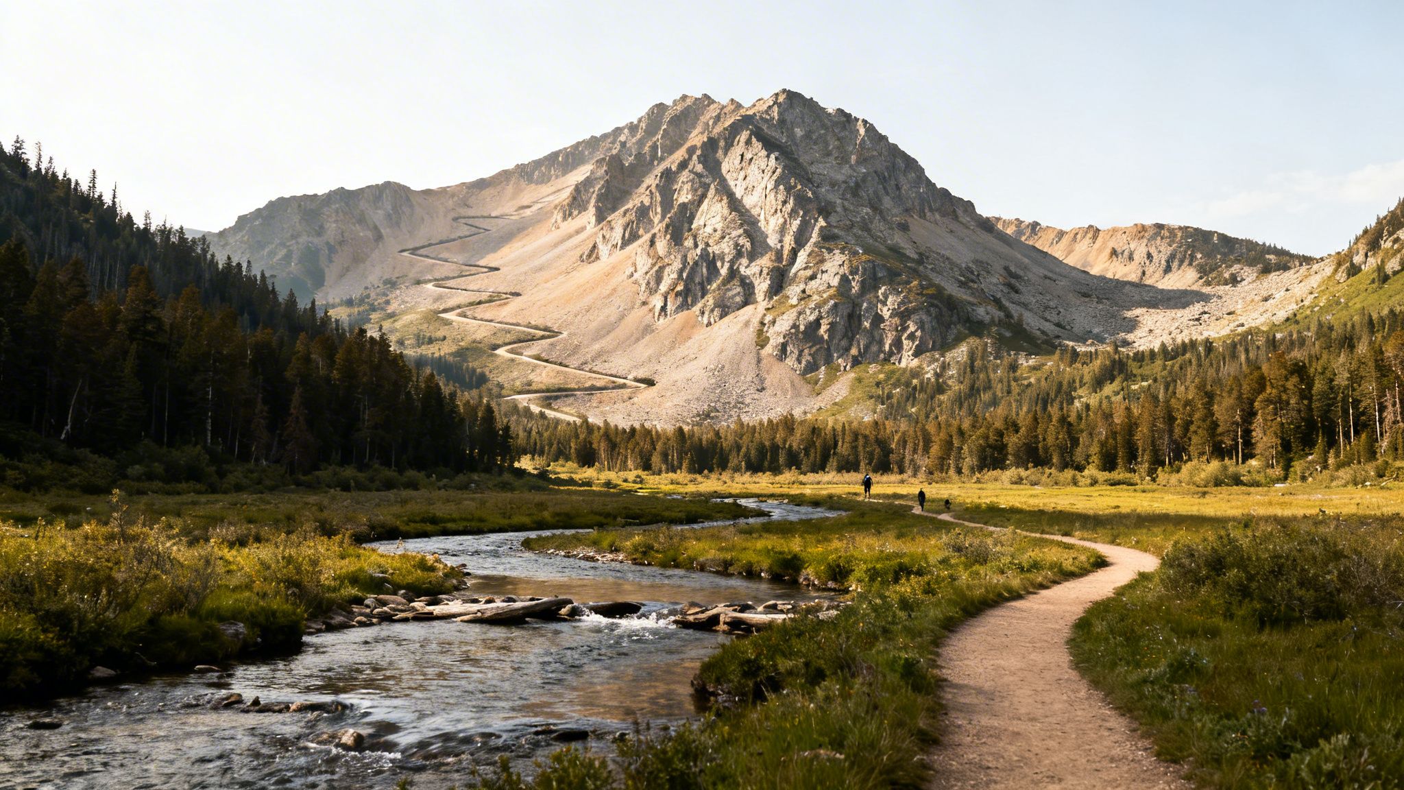
The full 26.4-mile journey braids together the Little Missouri, the Athens-Big Fork, and the Viles Branch trails. You can almost think of it as a three-act play: a gentle, riverside beginning, a grueling series of mountain climbs for the climax, and a quiet forest walk to bring you back to the start.
The Three Faces of the Loop
Each segment brings something unique to the table, testing different aspects of your trail fitness and grit.
- Little Missouri Trail: This is where you'll get your feet wet—literally. It’s famous for its scenic river walks and countless water crossings. The terrain here is mostly flat, making it a perfect warm-up or a much-needed cool-down.
- Athens-Big Fork Trail: Welcome to the heart of the beast. This is where the trail earns its notorious reputation, throwing a relentless series of steep, punishing ascents and descents at you. Don't expect many switchbacks; it's mostly straight up and straight down.
- Viles Branch Trail: The final leg feels like a sigh of relief. It's a mostly flat, quiet path that guides you through the forest, giving your legs a chance to recover as you head for the finish line.
When you add it all up, you’re looking at a serious challenge with over 4,000 feet of total elevation gain. It’s a true test of both physical and mental endurance.
The real magic of the Eagle Rock Loop is in its constant variety. Just when your legs are screaming from another brutal climb, the trail will suddenly drop you alongside a peaceful river. It's this dynamic terrain that keeps you on your toes and makes finishing feel like such a massive accomplishment.
A Trail with Deep Roots
The loop's history adds another layer of character. As Arkansas's longest backpacking loop, it winds through the massive 1.8-million-acre Ouachita National Forest. The trail itself follows parts of a 100-year-old postal route and old wagon roads, which explains why it often takes the most direct—and difficult—route over the nine mountains it crosses. You can read more about what makes it a bucket-list trip on Backpacker.com.
This historical layout is why the climbs are so unforgiving. The old timers weren't building gentle switchbacks; they were just trying to get from point A to point B as efficiently as possible.
To give you a clearer picture, here's a quick rundown of the key stats for the loop.
Eagle Rock Loop at a Glance
| Metric | Details |
|---|---|
| Total Distance | 26.4 Miles (42.5 km) |
| Total Elevation Gain | 4,000+ Feet (1,219+ m) |
| Component Trails | Little Missouri, Athens-Big Fork, Viles Branch |
| Number of Major Climbs | 6-9 (Primarily on Athens-Big Fork) |
| Location | Ouachita National Forest, Arkansas |
| Typical Duration | 2-3 Days Backpacking / 1 Day Trail Running |
This table should help you visualize the challenge ahead. It’s a tough trail, but an incredibly rewarding one.
A Segment-by-Segment Trail Breakdown
To really get a handle on the Eagle Rock Loop, you have to think of it as three completely different hikes stitched together. Each section—the Little Missouri Trail, the Athens-Big Fork Trail, and the Viles Branch Trail—has its own distinct personality. Once you understand what each one throws at you, you can plan your energy, ration your snacks, and truly soak in the experience.
The Little Missouri Trail: A Scenic Warm-Up
No matter where you park your car, your journey will likely start on the Little Missouri Trail. Think of this as the loop's gentle introduction, a relatively flat and beautiful path that traces the banks of the Little Missouri River. It’s a fantastic warm-up, letting you find your rhythm as you weave through lush forests with the sound of the river as your constant companion.
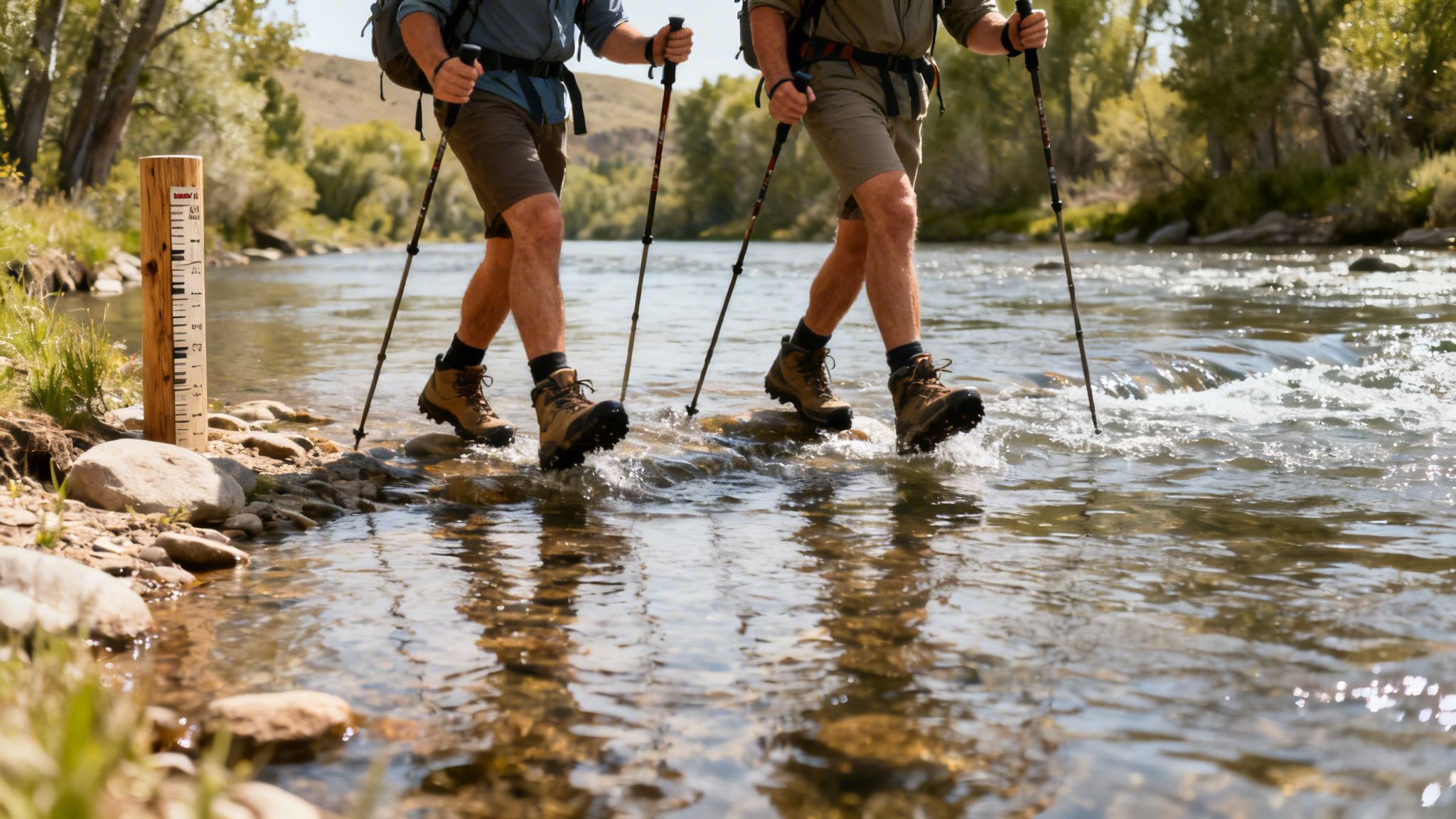
What really defines this section are the water crossings. There are a ton of them. Depending on how much rain has fallen recently, you might be rock-hopping across, or you could be wading in knee-deep water. It's a great way to ease your legs into the hike and get a real feel for the trail. Drink in the scenery here, because the real work is right around the corner.
The Athens-Big Fork Trail: The Heart of the Challenge
Alright, deep breath. This is it. The Athens-Big Fork Trail is where the Eagle Rock Loop earns its stripes as Arkansas's toughest hike. The moment you leave the river valley, the terrain shifts dramatically. Get ready for a relentless roller coaster of steep, quad-burning climbs followed immediately by knee-jarring descents.
This part of the loop is a pure test of grit. You'll tackle somewhere between six and nine major climbs, one right after another, with barely any switchbacks to give you a break. The trail pretty much just points straight up one side of a mountain and straight down the other.
I always tell people this segment isn't just a hike; it's a vertical puzzle. Each ascent is a new problem to solve with your body, and every descent tests your balance and joint strength. Getting through the Athens-Big Fork is the key to finishing the whole loop.
This is the rugged southwestern Ouachita National Forest at its finest. Over just eight miles, you'll cross six major ridges, racking up a cumulative elevation gain of over 4,000 feet. It's this unforgiving profile that brings people from all over to test themselves. You'll grind up major climbs, including a brutal 300-foot ridge overlooking the Albert Pike area, making this section an unforgettable sufferfest. You can get more details on why this demanding trail is so popular by checking out the guide on Paria Outdoor Products.
The Viles Branch Trail: A Welcome Reprieve
After battling your way through the Athens-Big Fork, the Viles Branch Trail feels like a gift. This final leg is your victory lap, a much-needed break that guides you back toward your starting point along a forgiving, mostly flat path. The gentle terrain lets your legs finally recover as you stroll through a peaceful, quiet forest.
Much like the Little Missouri Trail, you'll have several creek crossings, but these are often bone-dry depending on the season. It’s a quiet, reflective stretch of trail—the perfect opportunity to let the accomplishment of what you just did sink in. The Viles Branch is the perfect, mellow ending to an absolutely epic adventure.
Planning Your Hike: Logistics and Safety
A good trip on the Eagle Rock Loop is all about smart planning. While it's fantastic that the trail is free of permits and fees, that freedom comes with a responsibility to be prepared. The real work begins before you even lace up your boots, especially when it comes to the loop’s infamous water crossings.
One of the great things about this trail is its flexibility. You don't have to start at one specific spot, which helps spread people out and gives you options. The main trailheads are easy to find and have parking, but they definitely fill up fast on nice weekends.
Choosing Your Starting Point
There are four main trailheads, and each offers a slightly different way to start your adventure. Think about which direction you want to hike and what kind of terrain you want to tackle first.
- Little Missouri Falls Trailhead: A classic choice on the west side of the loop. It puts you right onto the scenic river trail from the get-go.
- Albert Pike Recreation Area: This spot on the east side has plenty of parking, but it's also a solemn reminder of the river's power, as it was the site of a devastating flash flood.
- Winding Stairs Trailhead: Found right in the middle of the river section, this is a great starting point if you want to jump straight into the heart of the action along the Little Missouri Trail.
- Viles Branch Equestrian Camp: Tucked away on the southern end, this is perfect if you want to knock out the flatter, easier Viles Branch section first.
The Most Critical Safety Check: River Crossings
If you take away only one piece of advice, let it be this: check the water levels of the Little Missouri River. This isn't just a friendly tip; it's the most important safety check you will make. A heavy rainstorm can transform this gentle river into a dangerous, raging torrent in just a few hours. Flash floods are a very real, very serious risk here.
Before you even think about leaving home, you need to check the USGS river gauge data for the Little Missouri River near Langley. This gauge is your go/no-go signal for the entire trip.
Safety Guideline: Most seasoned hikers won't even attempt the loop if the gauge reads above 4 feet. At that level, the current is much stronger than it looks, and the crossings can become downright treacherous, especially with a heavy pack on your back.
Think of this data as your lifeline. Just search for "USGS Little Missouri River Langley" to find the real-time river depth. Always have a backup plan. If the river is too high, it's not worth the risk. You can always explore other great trails in the Ouachita National Forest, like the beautiful Cascade Falls Trail, and save the loop for another day.
Seasons, Weather, and Finding a Campsite
The absolute best times to hike the Eagle Rock Loop are spring and fall. The temperatures are comfortable, the bugs are manageable, and the scenery is at its peak. Summer can be brutal, with high heat, suffocating humidity, and a ton of ticks and poison ivy. Winter offers solitude but comes with its own challenges, like freezing temperatures and icy trail sections.
You'll find plenty of established campsites all along the trail, especially along the river. These are all first-come, first-served, so you just have to find an open one. No matter where you camp, please follow Leave No Trace principles. Pack out everything you bring in, use existing fire rings, and make sure your tent is at least 200 feet from any water source to help protect this amazing place.
Gearing Up and Getting Ready for the Trail
Thinking you can just wing it on the Eagle Rock Loop is a classic mistake. I've seen it happen time and again—what should be an amazing trip turns into a brutal slog. To really enjoy this trail, you've got to put in the work beforehand, both with your gear and your training. This loop demands respect.
Your gear is your lifeline out there. If I had to pick one non-negotiable item, it's a reliable water filter. You'll be getting all your water from the rivers, so you need a way to make it safe. Right behind that is proper footwear. Get yourself a pair of solid hiking boots with good ankle support; your feet will thank you on the rocky, treacherous terrain of the Athens-Big Fork section.
Your Must-Have Gear List
Beyond the standard backpacking setup, a few specific items will make or break your trip on this particular trail. With zero cell service, getting lost is a real risk, so don't skimp on navigation.
- The Navigation Trio: A physical map, a compass, and a GPS device (or a phone with downloaded offline maps) are essential. Never, ever rely on just one.
- Water Crossing Shoes: A pair of camp sandals or dedicated water shoes will make the many river crossings much safer and more comfortable than trying to do it barefoot.
- Trekking Poles: Honestly, these are a lifesaver. They take a huge amount of strain off your knees on the relentless downhills and give you extra power on the climbs.
Training for the Grind
Your training plan needs to mirror what the trail is going to throw at you. Just putting in miles on a flat path isn't going to prepare you for this. The Athens-Big Fork trail is notorious for its brutally steep, punchy climbs that go straight up the mountain without switchbacks. Your body needs to be ready for that vertical abuse.
The point of training isn't just to survive the hike, but to be strong enough to actually enjoy it. When you simulate the trail's unique challenges, you're preparing both your body and mind for the reality of the loop, which helps prevent you from hitting a wall on the toughest climbs.
Start adding hill repeats and stair climbing to your workouts. This will build the specific leg strength and lung capacity you need to power through those climbs. If you really want to dial in your fitness, our guide on how to improve running endurance has some great techniques that translate directly to hiking this kind of terrain.
To get a sense of what's possible on this trail, just look at the Fastest Known Time (FKT) records. Elite trail runners have tackled the 26.8-mile loop at mind-boggling speeds. The men's FKT, held by Connor Chapdelaine, is an incredible 4 hours, 31 minutes, and 6 seconds. While most of us are backpacking this over a few days, these records show the raw athletic challenge the Eagle Rock Loop presents. You can see the full list of impressive times and dive into the route's FKT history.
Remember Your Hike with a Custom Map
Finishing the Eagle Rock Loop is a huge deal. It’s one of those hikes that tests you, and completing it is an achievement you'll want to remember long after the sore muscles have faded.
Instead of letting the memory live only in your phone's photo gallery, you can turn your adventure into a unique piece of art. The key is the GPS data you probably tracked along the way.
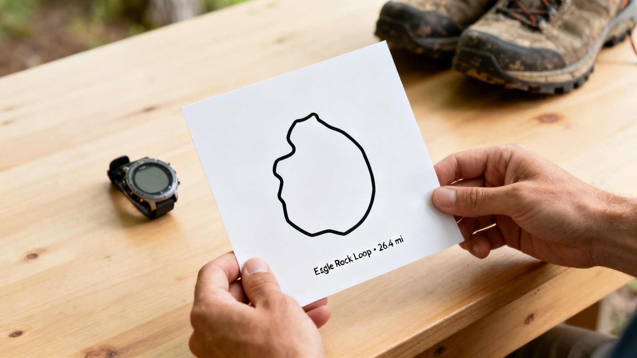
Turning Your GPS Data into Art
Every time you track a hike on a GPS watch or with an app like Strava, you create a digital footprint of your journey. That little data file contains every single climb, descent, and river crossing you tackled out there.
You can take that file and turn it into something real. One of the coolest ways to do this is to create a custom route poster that shows your exact path in a clean, minimalist style.
Services like RoutePrinter make it simple. You just upload your file and add personal details like your name, the date you hiked it, or your finish time.
It's a fantastic way to get a visual reminder of the mountains you climbed and the miles you put in on the Eagle Rock Loop.
The end result is a stylish print for your home or office—a great conversation starter and a source of pride that will get you pumped for your next big trip.
Eagle Rock Loop: Your Questions Answered
Even the most meticulously planned trip can leave you with a few lingering questions. Let's tackle some of the most common ones that come up for hikers getting ready to take on the Eagle Rock Loop.
So, How Hard Is This Trail, Really?
Don't underestimate this one—it's a beast. While you'll get some "easy" miles along the Little Missouri and Viles Branch trails, the Athens-Big Fork section is a different story entirely. It's a relentless roller coaster of six to nine steep mountain climbs, adding up to over 4,000 feet of total elevation gain.
This loop has a reputation as one of the toughest hikes in Arkansas for a reason. It demands a high level of physical fitness and a whole lot of grit.
Is This A Good Trail For Beginners?
In a word: no. This trail is not recommended for anyone just starting out with backpacking. The mix of brutal climbs, numerous river crossings that can become treacherous, and the trail's sheer remoteness is a serious combination.
It's much better to build up your skills and confidence on less demanding trails before you even think about tackling this loop.
The single biggest make-or-break factor on this trail is the water crossings. The Little Missouri River can swell from a gentle stream to a dangerous, fast-moving river in no time. Always, always check the USGS water gauge before you leave home.
What's The Best Time Of Year To Go?
Spring and fall are definitely the sweet spots. You’ll get milder temperatures and the Ouachita National Forest is at its most beautiful.
Summer is incredibly hot and humid, and you'll be battling ticks and poison ivy the whole way. Winter is certainly doable, but you need to be fully prepared for freezing temperatures and potentially icy, slick trail conditions. The Eagle Rock Loop is open year-round, but your best bet for an enjoyable trip is during those shoulder seasons.
Turn your hard-earned miles into a work of art. At RoutePrinter, we transform your GPS data from hikes like the Eagle Rock Loop into a custom, minimalist poster that celebrates your achievement. Create your personalized trail map today.