Finding the Best State Parks for Unforgettable Adventures

The best state parks aren't just the ones with the prettiest views. They're the ones that perfectly match what you need for your run, hike, or ride. Think of the relentless climbs at Watkins Glen State Park in New York, a dream for trail runners, or the sprawling paved bike paths at Panther Creek State Park in Tennessee.
Your ideal park is a training partner. It has the right terrain, elevation, and facilities to help you crush your goals.
Matching Your Adventure Goals to the Perfect Park
The secret to an epic day out is picking the right spot. This isn't just about finding a park with five-star reviews; it's about digging into what that park offers and seeing if it aligns with what you're trying to accomplish. What works for a marathoner looking for long, flat miles is totally wrong for a cyclist training for a mountain race.
Think of it as setting the stage. Before you even glance at a map, get a clear picture of your mission. Are you prepping for a technical trail race with gnarly roots and rocks, or do you just need a peaceful long run with minimal hills?
Defining Your Training Needs
First things first, get specific. A vague goal like "get a good workout" won't help you much. A better one? "Run 10 miles with 1,500 feet of elevation gain." That kind of clarity instantly narrows down the possibilities.
Consider these key factors:
- Terrain Type: Do you need smooth pavement for speed work, crushed gravel for a steady bike ride, or technical single-track for a challenging trail run?
- Elevation Profile: Are you hunting for big climbs, gentle rolling hills, or a pancake-flat route for a recovery day?
- Essential Amenities: Don't overlook the basics. Access to restrooms, water fountains, and reliable cell service can be a lifesaver on longer outings.
A triathlete, for example, might be on the lookout for a park with both tough bike loops and shaded running trails. On the other hand, a hiker training for a multi-day backpacking trip will prioritize parks with rugged terrain and spots for overnight camping. If you're just starting out or looking for a more relaxed day, our guide on finding easy hiking trails can point you in the right direction.
The real magic happens when you find a location that not only challenges you physically but also gets you fired up mentally. A park that ticks both boxes turns a grueling workout into an experience you’ll want to repeat.
Uncovering Local Gems
Once you know what you’re looking for, it’s time to do a little digging. Sure, big national publications have their lists, but the real gems are almost always found through local beta.
Hop into online forums for regional running clubs or cycling groups. These are gold mines of firsthand knowledge about trail conditions, how crowded a place gets, and those hidden routes you won't find on the main map.
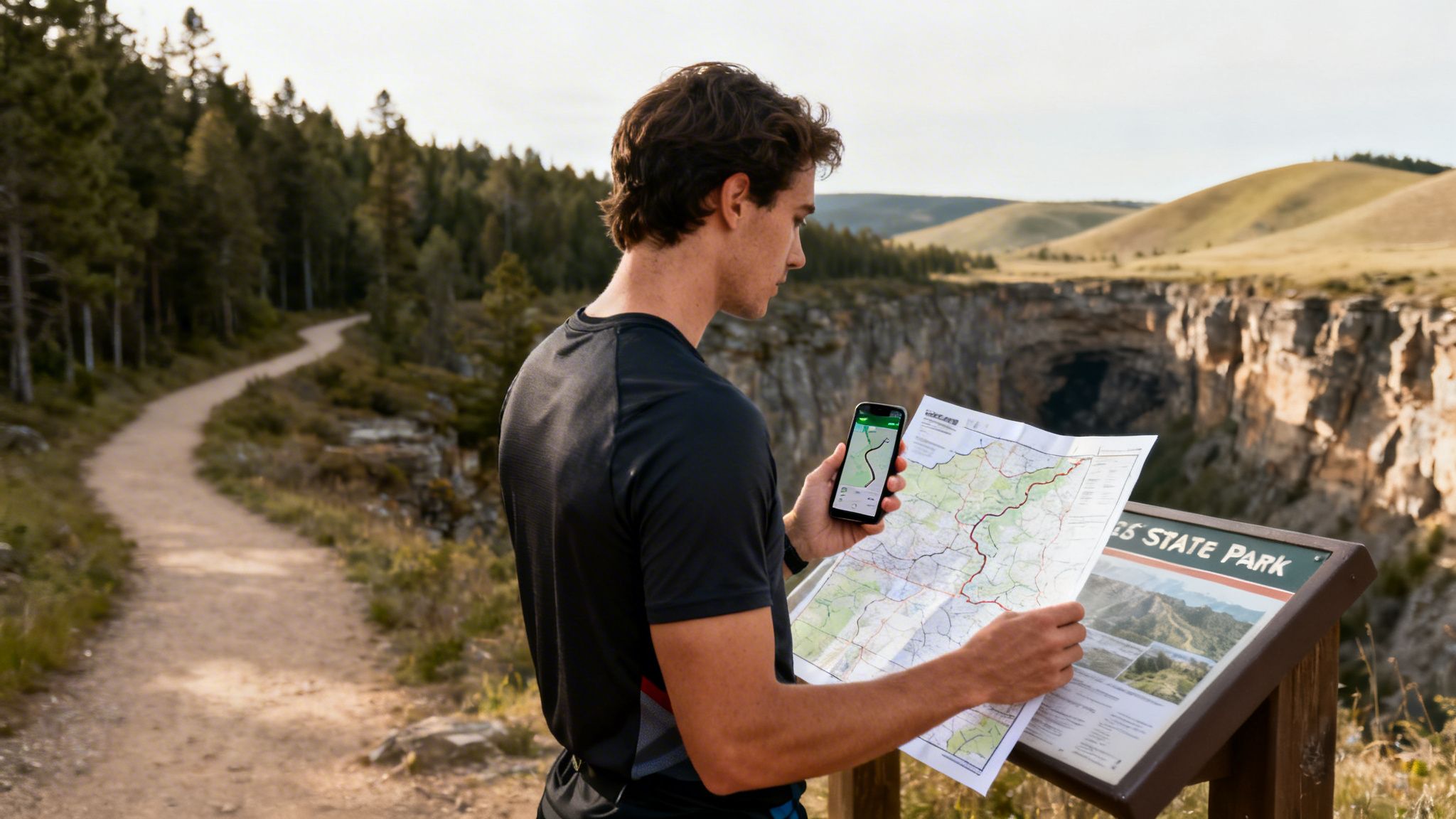
Trail apps are your other best friend here. Filter your searches by distance, elevation gain, and user ratings to quickly zero in on promising parks. I always make a point to read recent reviews and look at user-submitted photos—they give you the real-time scoop on what to expect when you get there. This groundwork ensures you find a park that isn’t just beautiful, but is the perfect arena for your next adventure.
Designing a Route That Inspires
Alright, you've picked a great state park. Now for the fun part: turning that beautiful landscape into your own personal adventure. This is where the artistry comes in, crafting a route that’s not just safe and challenging, but genuinely exciting. Just showing up and wandering isn’t a plan; it's a surefire way to miss the best parts or, worse, get into a tricky situation.
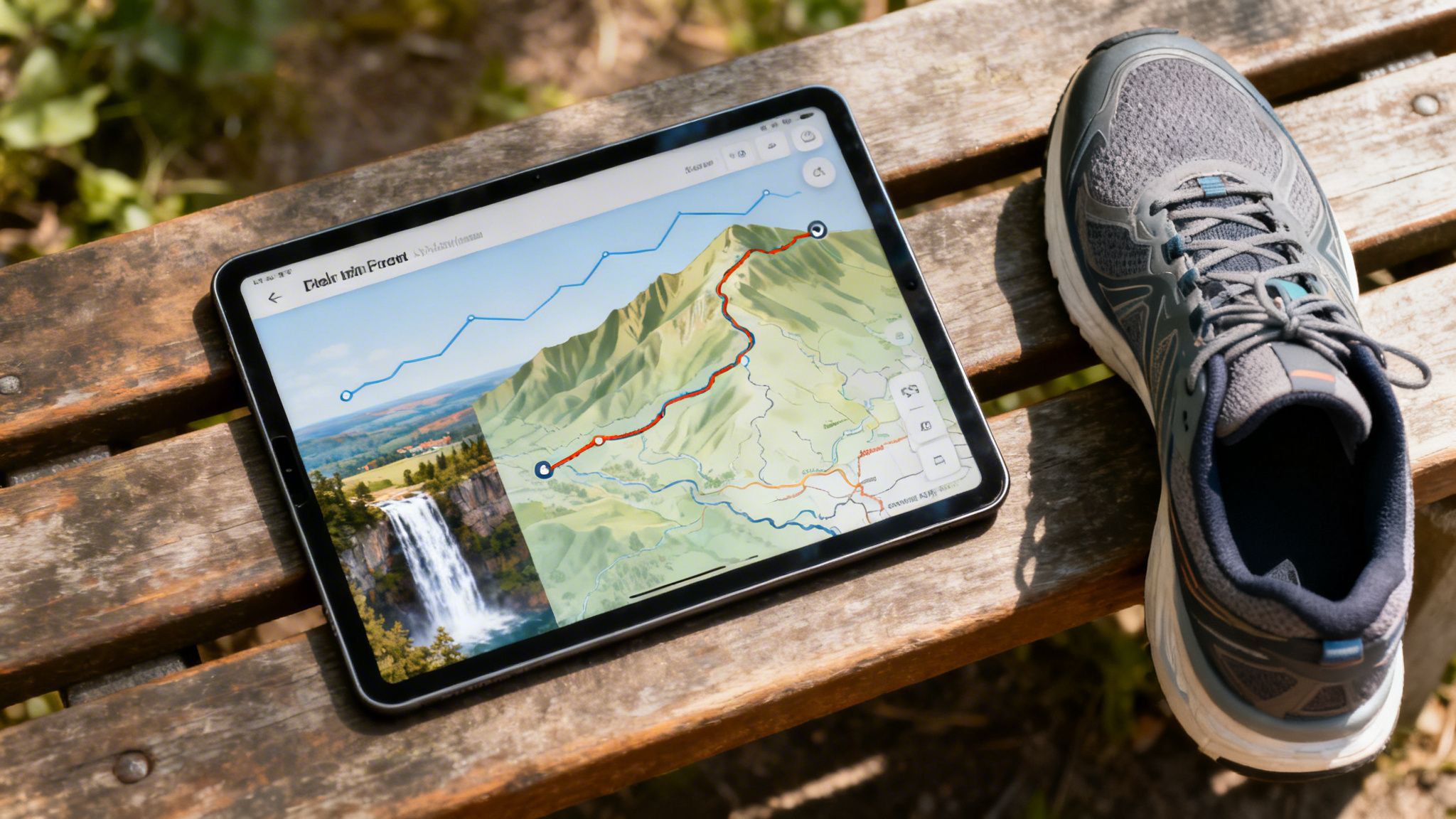
This is where modern mapping tools like Strava's Route Builder or Gaia GPS become your best friends. They're like a digital canvas, letting you move beyond guesswork and start making smart decisions. Before you even lace up your shoes, you can see every climb, every descent, and every turn. That kind of foresight is what helps you manage your energy and stay well within your limits.
Laying the Groundwork for a Safe Adventure
Safety has to be at the top of the list, and a well-planned route is your first line of defense against the usual problems. You want to finish feeling accomplished, not completely drained and disoriented.
One of the biggest game-changers is looking at the elevation profile beforehand. It helps you see the big climbs coming, so you don't go out too hard and bonk miles from the finish line.
Always check for current trail conditions before you commit. Most park websites, like the one for Tennessee State Parks, post real-time updates on closures or hazards. I also like to scroll through recent user reviews on trail apps—they're an amazing source of intel on everything from downed trees to washed-out bridges.
And the final, most important step: share your plan. Send your route, estimated start and finish times, and your location to a friend or family member. It’s simple, but it’s one of the most critical safety nets you have.
Building a Route That Tells a Story
A really great route is more than just a line on a map; it's a story. Why just run a random loop when you can run to something? The best routes have a purpose, linking together points of interest that make the whole journey feel meaningful. This is how a tough workout becomes a true exploration.
Think about what makes a park special and build your route around its crown jewels.
- Scenic Overlooks: I love planning my routes to hit a big panoramic viewpoint right at the halfway point. It’s a perfect spot to catch your breath and a huge motivator when you’re grinding up a tough climb.
- Waterfalls or Landmarks: Try designing a path that follows a creek down to a waterfall or loops past a historic site. These kinds of features add chapters to your adventure's story.
- Varied Terrain: Keep things from getting monotonous by mixing different trail types. A blend of technical single-track, wide fire roads, and rolling hills makes for a much more engaging day out.
For instance, instead of a boring out-and-back, you could map out a lollipop loop that takes you to the park’s highest peak. Or for a long bike ride, you could link several smaller loops that all return to a central point, letting you refuel without carrying a ton of supplies. For a great example of a route that combines tough terrain with incredible scenery, check out our breakdown of the challenging Eagle Rock Loop.
A thoughtfully designed route doesn't just guide your feet—it focuses your mind. When every turn reveals something new, your effort is rewarded with discovery, turning miles into memories.
Ultimately, your route is the blueprint for your achievement. By taking the time to plan a path that balances safety, challenge, and pure scenic beauty, you're setting yourself up for an experience you'll want to remember forever.
A Case Study: Watkins Glen State Park
Let's put this all into practice with a real-world example. I want to walk you through one of America’s most incredible outdoor spaces, Watkins Glen State Park in New York. This place is so much more than a pretty spot for a picnic; it’s a legitimate training ground that mixes raw, natural beauty with a serious physical test. It’s exactly the kind of place that makes for an unforgettable adventure.
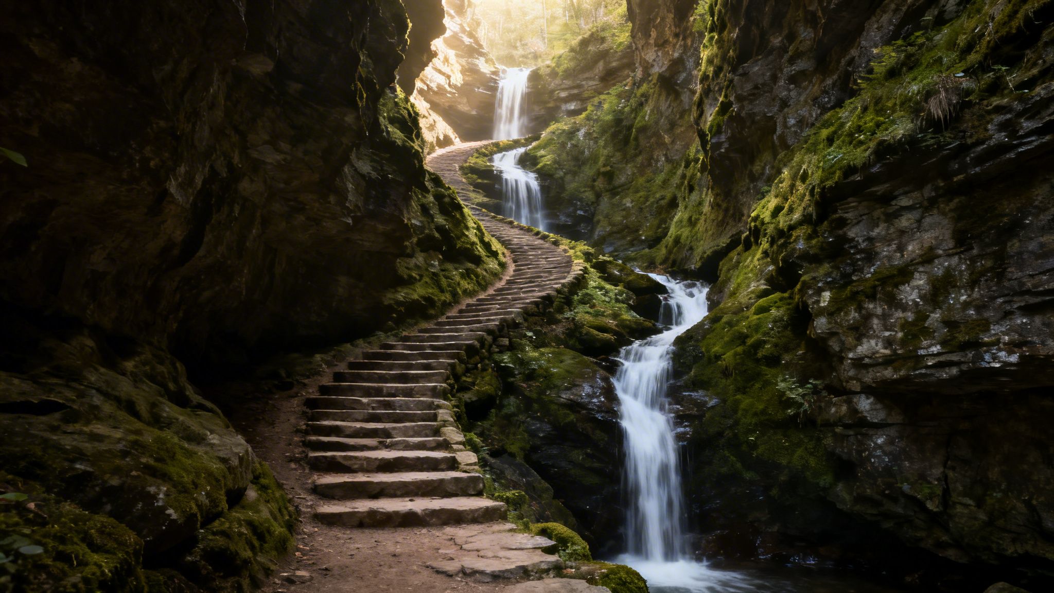
The crown jewel of the park is its Gorge Trail, which feels like it was lifted straight out of a fantasy epic. For an athlete, its appeal isn't just the jaw-dropping scenery—it’s the relentless challenge. The trail is a masterclass in technical, constantly changing terrain that forces you to stay sharp.
The Anatomy of a Perfect Challenge
Let’s say you’re planning a route here. Your objective: a full out-and-back trek of the Gorge Trail. The numbers alone paint a pretty vivid picture. We’re talking about 4 miles of intense hiking or running, broken up by more than 800 stone steps on the ascent and another 800 on the descent.
This is not your average trail run. It's a grueling, quad-burning stair workout set against the backdrop of cascading waterfalls.
The constant up-and-down of the steps, often on wet, mossy stone, demands precise footwork and core stability. It builds a kind of functional strength that you just can't get on a flat road or a manicured path. Plus, the narrow trail winding between towering cliffs adds a mental element—you have to be fully present and aware of your surroundings.
This unique combination makes Watkins Glen a prime spot for a landmark effort. It's no wonder the park's Gorge Trail was named the most visited in the U.S. in 2023. This incredible two-mile path in the Finger Lakes region features 19 waterfalls plunging through a deep canyon. You get so close you can feel the spray. You can discover more about its award-winning status and what makes it such a bucket-list destination.
The real beauty of a place like Watkins Glen is that the landscape is the workout. You don't need a formal training plan; the trail itself provides the intervals, the climbs, and the recovery. It’s pure, reactive training.
To get a better sense of how you might approach this, here’s a breakdown of the park’s main trails and how they stack up for different training goals.
Watkins Glen Trail Analysis for Athletes
This table breaks down the primary trails at Watkins Glen and their suitability for different types of endurance training.
| Trail Name | Key Features | Best For | Training Benefit |
|---|---|---|---|
| Gorge Trail | 800+ stone steps, 19 waterfalls, wet surfaces, narrow paths | Hiking, Technical Trail Running | Power, agility, high-intensity intervals, mental focus |
| Indian Trail | Runs parallel to the gorge but on the rim; less technical | Steady-State Running, Hiking | Endurance, sustained effort, scenic views without technicality |
| South Rim Trail | Forested path, dirt surface, rolling hills | Trail Running, Long Hikes | Stamina building, less crowded, good for longer endurance sessions |
| Finger Lakes Trail | Connects to the park, part of a larger trail system | Ultra-marathon Training | Long-distance endurance, varied terrain, self-supported training |
Each trail offers a completely different experience. By combining them—say, an intense out-and-back on the Gorge Trail followed by a cooldown run on the Indian Trail—you can build a truly comprehensive and memorable workout.
Crafting a Route for Visual Impact
Now, picture what this route looks like on a GPS map from an app like Strava. It’s not a simple loop or a straight shot. The GPS track of the Gorge Trail is a jagged, intricate line that coils through the narrow canyon, visually capturing every single twist, turn, and climb you battled through.
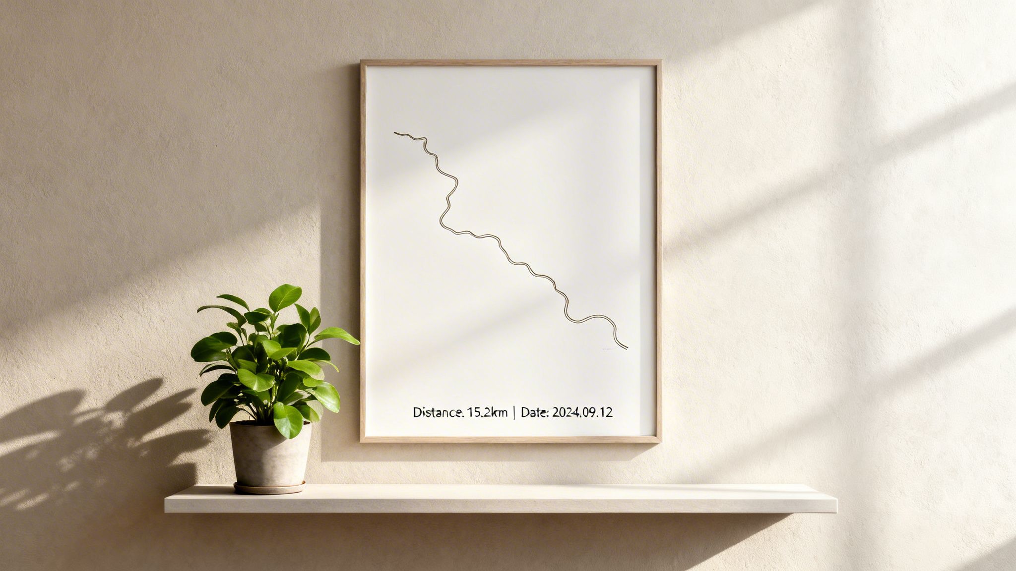
When you take that data and create a RoutePrinter poster, the map tells an immediate and powerful story. That winding line isn't just a path; it's a testament to your effort in a demanding environment. The final piece of art is more than just a souvenir—it’s a visual record of your strength, immortalizing an incredible day in one of the country's best state parks.
Capturing Your Journey With Precision
An epic adventure in a stunning state park deserves to be remembered. After all that planning, the next step is to accurately record every step, pedal, or stride of your route. This GPS track is more than just data; it's the raw material for your story and the blueprint for a truly personal piece of art.
Most of us use an app like Strava to do this. But getting a clean, accurate track out in the wild isn't always as simple as hitting "start." Dense tree cover, deep canyons, or just being way off the grid can wreak havoc on GPS signals, leaving you with a jagged, frustratingly inaccurate map of your big day out.
Mastering the Art of the GPS Track
To make sure your final map truly reflects your effort, you need to give your device the best possible chance to get a good signal. It's one of those small details that makes a massive difference in the end.
I’ve learned a few tricks over the years to help maintain a strong signal:
- Get a clear view first. Before you disappear into the woods, give your watch or phone a minute or two with a wide-open view of the sky. This lets it lock onto multiple satellites, giving you a strong, solid fix right from the get-go.
- Keep your device up high. If you're using your phone, an armband or a pocket on your pack's shoulder strap works way better than burying it deep inside your bag. It’s a simple change that keeps it exposed to the sky.
- Turn on multi-band GPS. Many newer watches and phones have a feature called multi-band or dual-frequency GPS. It’s a game-changer. It uses multiple satellite frequencies to filter out bad signals that bounce off canyon walls or tall buildings, resulting in a much smoother, more accurate track.
An accurate GPS track does more than just prove your mileage. It captures the real personality of your route—every single switchback and climb—creating a visual story that's both powerful and uniquely yours.
Going Beyond the Basic Map
Tracking your route is just where the fun begins. Strava is full of features that can add a whole new layer to your adventure, both while you're out there and after you're done.
For instance, turning on Live Segments before a big climb can add a little dose of friendly competition to your effort. It's a great motivator to see how your time stacks up against others who have tackled the same iconic hills in that park.
And don't forget your camera! Adding photos to your activity turns a simple page of stats into a vivid story. Snap a picture at that incredible overlook or by the waterfall you routed past. Those are the moments that truly capture the feeling of the day.
Analyzing Your Epic Effort
Once you’ve hit "save," the real fun of digging into the data begins. Look past the obvious metrics like pace and distance to understand the full story of your performance.
- Grade-Adjusted Pace (GAP): This is a fantastic metric. It estimates your pace as if you were on flat ground, giving you a much truer sense of your effort on a super hilly route.
- Heart Rate Analysis: If you train with a heart rate monitor, you can pinpoint exactly where you pushed your limits and where you were in recovery mode. It adds a fascinating physiological layer to the story of your journey.
This detailed log—complete with an accurate map, photos, and performance data—is the perfect foundation. It’s everything you need to turn those hard-earned miles into a piece of personalized art that celebrates your achievement.
Transforming Your GPS Track Into Lasting Art
You did it. The planning paid off, the effort was worth it, and the memory of that perfect day exploring a state park is still fresh. The sweat has dried and your legs have recovered, but you're left with an incredible sense of accomplishment. Now, how do you hold onto that feeling?
You can turn that fleeting experience into something tangible and permanent—a piece of modern art that hangs on your wall as a daily reminder of what you can do.
That GPS track you so carefully recorded isn't just a bunch of data points. It's the unique signature of your adventure, a squiggly line that tells a story of every hill, turn, and scenic viewpoint. With a service like RoutePrinter, you can transform that digital line into a beautiful, high-quality poster.
From Strava Activity to Wall Art
I've done this a few times, and the process is surprisingly simple. You just connect your Strava account, which lets the platform see your activity history. Then comes the fun part: scrolling through your past runs, hikes, and bike rides to find the one.
Maybe it was that brutal, rewarding climb at Watkins Glen, or that blissfully flat, long run along the coast. Once you’ve picked your activity, you get to be the artist. You’re not just printing a map; you’re designing a custom memento that tells your unique story.
You can add all the little details that matter to you:
- The Title: Give it the official name or something more personal, like "My First 50k" or "Conquering Mount Tam."
- The Date: Lock in the day you made it happen.
- Key Stats: Showcase the challenge by adding your finish time, total distance, or elevation gain.
These personal touches are what make it special. It stops being just a map and becomes a real piece of your story. If you need some inspiration, check out these creative race poster ideas to see how others have framed their achievements.
Choosing a Style That Fits Your Space
A great commemorative print should look as good as it makes you feel. Before you choose a design, think about where it’s going to hang. Your home office? The pain cave? Your living room?
You can choose a style that actually fits your home's decor. I’m a big fan of the minimalist black-and-white designs for a clean, modern vibe. But you could also go for a color scheme that matches the earthy tones of the park you explored. The whole point is to create something you’re genuinely proud to display.
Your GPS track is more than a line on a map; it's a visual diary of your perseverance. Displaying it turns a digital memory into a daily source of motivation.
Ultimately, this is about honoring your own hard work. You're immortalizing a specific moment in time, capturing the heart of your adventure in a single, elegant image. That poster on your wall becomes more than just decoration—it’s a constant reminder of what you’re capable of.
A Few Common Questions Answered
When you're gearing up for a big day out in a state park, a few questions are bound to pop up. Whether you're figuring out which trail to tackle or how to best capture the memory, I’ve got you covered with answers to some of the most common queries.
"I'm New to This Park. How Do I Find a Trail That's Right for Me?"
This is a great question, and getting it right is key to having a good time. I always start with an app like AllTrails or Komoot. They let you filter everything—difficulty, distance, even how much climbing is involved—so you can quickly narrow down your options.
But here’s the pro tip: always, always read the most recent user reviews. They are gold. You'll get the real story on trail conditions, whether that "moderate" rating feels more like "hard," or if a key bridge is washed out. For your first visit, I’d strongly recommend picking a route that feels just a little easier than what you'd normally do. It’s about enjoying the scenery and staying safe, not pushing your absolute limit in an unfamiliar place.
I can't tell you how many times I've seen experienced athletes get humbled by a new environment. A trail that looks straightforward on a map can be a whole different animal on the ground. Starting conservatively is the smartest move you can make.
"My GPS Signal Was Spotty and My Route Map Looks a Bit Jagged. Will My Poster Look Bad?"
Not at all. In fact, it happens to all of us. Those little GPS wobbles and jagged points rarely detract from the final print. The beauty of the poster is in the overall shape and story of your route, so those minor imperfections usually just fade into the background. Sometimes, that raw, slightly messy track feels even more authentic—a true reflection of the adventure.
If you have a really significant error, like a long straight line cutting across the landscape where your signal dropped, you can clean it up. Strava has a "Correct Distance" feature that can help smooth things out. You can also use other tools to edit the file before creating your print.
"I Forgot to Track My Adventure on Strava. Can I Still Make a Poster?"
You absolutely can. This is a common one, and there are a couple of easy workarounds.
If you tracked your activity on a different device, like a Garmin or Suunto watch, you probably have a GPX file. Just upload that file directly to your Strava account, and you're good to go.
What if you have no GPS file at all? No problem. Use Strava's Route Builder tool to manually trace the path you took. It’s surprisingly simple to recreate your journey from memory, giving you a clean map that’s ready for printing. This way, no incredible adventure ever gets forgotten.
Ready to turn those hard-earned miles into something you can hang on your wall? Head over to RoutePrinter and see how easy it is to transform your favorite run, hike, or ride into a beautiful, personalized piece of art.