The 12 Best Hiking Places in the World for Your 2026 Bucket List

Embarking on a journey to find the world's most breathtaking trails can be a life-altering experience. Whether you dream of conquering jagged alpine peaks, trekking through the ruins of ancient civilizations, or immersing yourself in remote, untouched wilderness, this guide to the best hiking places on Earth has something for every type of adventurer. We have curated a definitive list of iconic global treks, moving beyond simple descriptions to provide the actionable details you need to start planning.
This is more than just a list; it's a practical blueprint for your next great escape. For each of the 12 world-class destinations featured, we deliver a comprehensive breakdown designed for serious planners and dedicated athletes. You will find:
- Concise Trail Summaries: Get a clear picture of the landscape and what makes each hike unique.
- Actionable Logistics: We cover essential travel tips, permit requirements, and the best seasons to visit.
- Route-Specific Details: Discover key segments, elevation profiles, and difficulty ratings to match your skill level.
- Strava-Friendly Notes: Learn about specific sections perfect for tracking and sharing your accomplishments.
Each destination offers a unique challenge and a profound reward, creating memories that will last a lifetime. Our goal is to equip you with the knowledge to not only choose a trail but to confidently prepare for it. Let's lace up our boots and explore the trails that belong on every dedicated hiker's bucket list, transforming your adventure from a dream into a well-planned reality.
1. The Inca Trail, Peru
The Inca Trail to Machu Picchu is arguably one of the most famous and best hiking places in the world. This ancient 26-mile (43-kilometer) path winds through the Andes Mountains, combining breathtaking scenery, lush cloud forests, and a direct link to pre-Columbian history. The trek culminates at the Sun Gate (Inti Punku) for a sunrise view over the iconic Machu Picchu citadel, a reward that makes the challenging journey unforgettable.
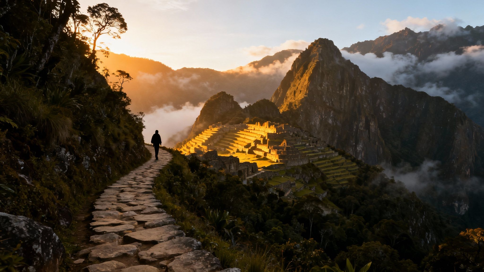
This multi-day hike is not just a walk; it's a pilgrimage through history, passing smaller ruins and settlements along the way. Its unique blend of adventure, culture, and natural beauty solidifies its place on any serious hiker's bucket list.
Trail Details & Logistics
- Difficulty: Moderate to Challenging
- Distance: 26 miles (43 km)
- Elevation Gain: Varies, with the highest point at Dead Woman's Pass (13,828 ft / 4,215 m)
- Best Season: The dry season, from May to September.
- Key Tip: Booking a tour with a licensed guide is mandatory for the Classic Inca Trail. Permits sell out 6-12 months in advance, so plan far ahead.
Actionable Advice for Your Trek
Before you go, it is crucial to acclimatize to the altitude in Cusco for at least two to three days to prevent altitude sickness. To prepare your body, incorporate cardiovascular training and practice hiking on varied terrain with a weighted backpack. For a post-hike celebration, capture your Strava-recorded route and turn it into a custom piece of art. A RoutePrinter poster can immortalize the iconic trail map, complete with your personal stats like distance and elevation, creating a perfect memento of your epic journey.
2. Torres del Paine, Chile
Deep in Chilean Patagonia, Torres del Paine National Park is an otherworldly landscape of jagged granite peaks, vibrant turquoise lakes, and immense glaciers. This destination is one of the best hiking places for those seeking raw, untamed wilderness. The park’s famous "W Trek" is a world-class journey that guides hikers through some of the most dramatic alpine scenery in South America, offering a sense of profound isolation and natural grandeur.
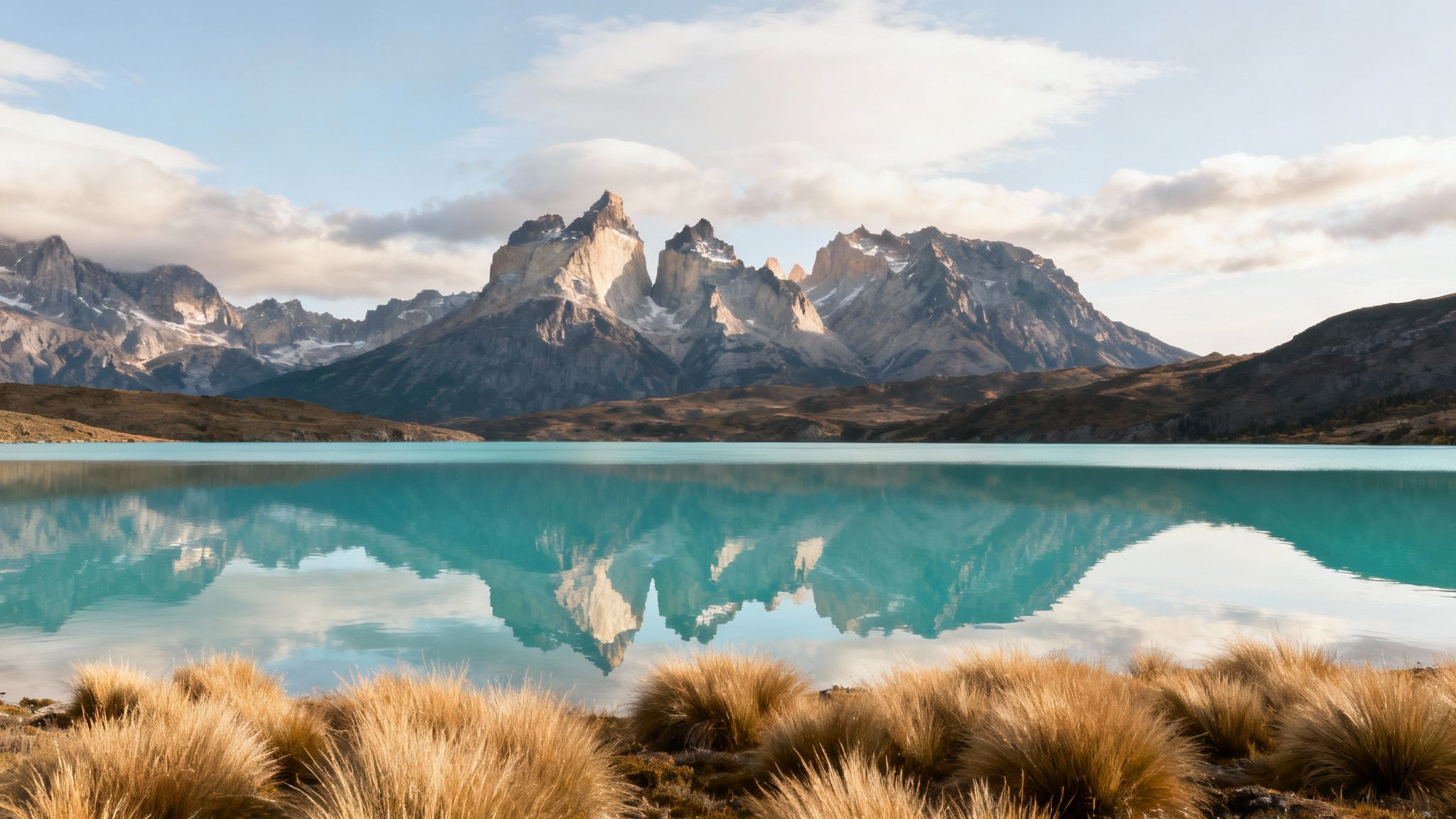
This trek is an iconic Patagonian adventure, connecting three stunning valleys shaped like a 'W'. Each leg of the journey reveals a new highlight, from the soaring granite towers that give the park its name to the colossal Grey Glacier. It's a true immersion into one of the planet's most spectacular and pristine environments.
Trail Details & Logistics
- Difficulty: Moderate to Challenging
- Distance: Approx. 50 miles (80 km) for the W Trek
- Elevation Gain: Significant cumulative gain, varies by direction and route
- Best Season: The Patagonian summer, from December to February, offers the best weather.
- Key Tip: Accommodations (campsites or refugios) must be booked far in advance, especially during peak season, as they have limited capacity and fill up quickly.
Actionable Advice for Your Trek
Patagonia's weather is notoriously unpredictable, so packing multiple weather-resistant layers is essential. Even in summer, you can experience sun, rain, and powerful winds in a single day. Start your daily hikes early to avoid the infamous afternoon winds, which can be incredibly strong. To commemorate your accomplishment, transform your Strava data from the W Trek into a personalized memento. A RoutePrinter map of your journey is a perfect way to visualize the scale of your Patagonian expedition, capturing every valley and viewpoint.
3. Appalachian Trail, USA (Eastern United States)
Stretching over 2,190 miles (3,524 kilometers) from Georgia to Maine, the Appalachian Trail (A.T.) is a legendary trek and one of the best hiking places for those seeking a true long-distance challenge. As the longest hiking-only footpath in the world, it traverses 14 states, offering an incredible variety of landscapes from the rolling southern mountains to the rugged, wild forests of New England. The A.T. is more than a trail; it's a cultural icon with a vibrant community of thru-hikers, section hikers, and "trail angels."
Whether you tackle a scenic section for a weekend or commit to the epic five-to-seven-month thru-hike, the A.T. delivers an unforgettable immersion into the American wilderness. Its accessibility and well-established network of shelters and trail towns make it a feasible, albeit demanding, adventure of a lifetime.
Trail Details & Logistics
- Difficulty: Challenging to Strenuous (Varies by section)
- Distance: Approx. 2,190 miles (3,524 km)
- Elevation Gain: Over 464,500 feet (141,580 m) - equivalent to climbing Mt. Everest 16 times
- Best Season: For northbound thru-hikes, start in March-April. For section hiking, summer and early fall are ideal.
- Key Tip: Plan your resupply strategy carefully. Trail towns are your lifeline for food, gear, and rest, but they can be several days' hike apart.
Actionable Advice for Your Trek
Thru-hiking the A.T. is an ultra-endurance event that requires significant physical and mental preparation. Your training should focus on building stamina through long-distance hiking with a full pack, mimicking the daily grind you'll face on the trail. For a comprehensive look at building this kind of endurance, you can explore training principles similar to marathon preparation. After completing a section or the entire trail, a custom RoutePrinter map displaying the jagged elevation profile and the states you crossed is the ultimate way to commemorate such a monumental achievement.
4. Mont-Blanc Massif, France/Italy/Switzerland
The Mont-Blanc Massif, a breathtaking expanse of jagged peaks, sprawling glaciers, and pristine valleys spanning three countries, is home to some of the best hiking places in Europe. Dominated by the continent's highest summit, this alpine wonderland offers everything from challenging multi-day treks like the Tour du Mont Blanc to accessible day hikes with stunning vistas. It's a landscape that captivates both seasoned mountaineers and casual trekkers alike.
The allure of this region lies in its sheer scale and the raw, untamed beauty of its high-alpine environment. Whether you're circumnavigating the entire massif or ascending a single peak, the combination of dramatic scenery, charming mountain refuges, and rich alpine culture makes for an unforgettable adventure.
Trail Details & Logistics
- Difficulty: Varies (Easy day hikes to Very Challenging mountaineering)
- Distance: Varies widely; Tour du Mont Blanc is ~105 miles (170 km)
- Elevation Gain: Varies; the summit of Mont Blanc is 15,771 ft (4,808 m)
- Best Season: Late June to early September for most hiking trails.
- Key Tip: Mountain refuges (huts) are essential for multi-day treks and must be booked months in advance, especially for July and August.
Actionable Advice for Your Trek
Proper acclimatization is critical for any high-altitude objective in the massif. Spend several days hiking at progressively higher elevations before attempting major ascents. The weather can change in an instant, so start your hikes early to avoid common afternoon thunderstorms and always monitor forecasts closely. For technical routes or a summit attempt, hiring a certified guide is strongly recommended for safety. To commemorate a journey like the Tour du Mont Blanc, consider a RoutePrinter map of your Strava-tracked adventure. It’s a stylish and personal way to display the incredible circuit you conquered.
5. Milford Track, New Zealand
Often described as "the finest walk in the world," the Milford Track is a pilgrimage through the heart of New Zealand's Fiordland National Park. This 33.5-mile (54-kilometer) journey showcases some of the planet's most dramatic landscapes, from glacially-carved valleys and lush temperate rainforests to cascading waterfalls and pristine mountain lakes. The trail offers a meticulously managed wilderness experience, making it one of the best hiking places for those seeking epic scenery with well-maintained facilities.
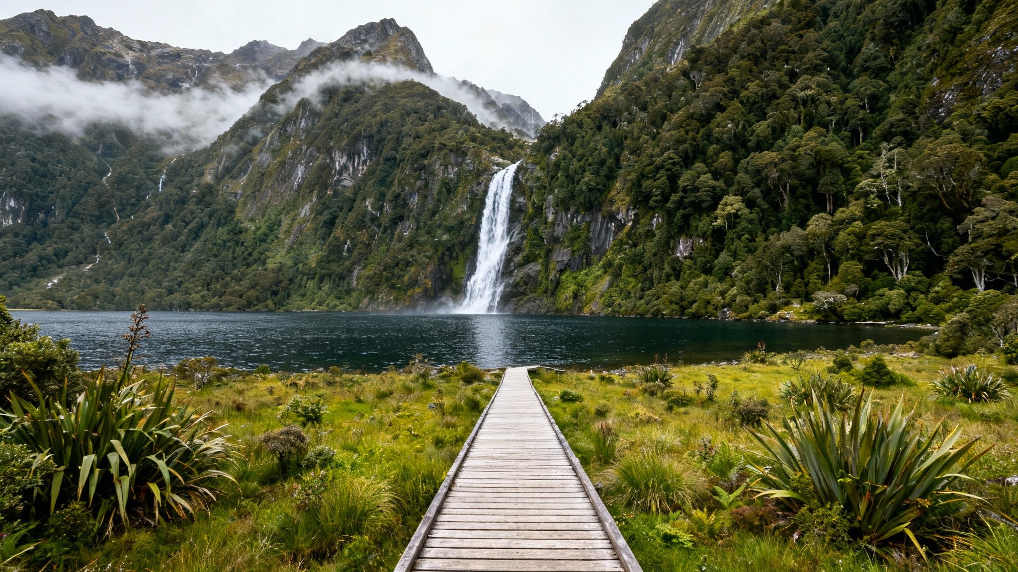
This hut-to-hut trek is designed to be walked in one direction, ensuring a sense of solitude and immersion in the wild. Its combination of accessibility and jaw-dropping beauty, including the towering Sutherland Falls, solidifies its legendary status among the global hiking community.
Trail Details & Logistics
- Difficulty: Moderate
- Distance: 33.5 miles (54 km)
- Elevation Gain: Varies, with the highest point at Mackinnon Pass (3,786 ft / 1,154 m)
- Best Season: The Great Walks season, from late October to late April.
- Key Tip: Hut bookings are essential and open in June each year, often selling out within minutes for the entire season. Be ready to book the moment they are released.
Actionable Advice for Your Trek
Your biggest challenge may be the weather, as Fiordland is one of the wettest places on Earth. Pack high-quality, reliable waterproof gear, including a pack liner, rain jacket, and pants. Train by hiking on uneven and muddy trails to prepare your ankles for the varied terrain. For those who conquer this iconic route or other nearby challenges, a great way to celebrate is with a custom New Zealand adventure poster. You can visualize your exact Strava route, turning the map of your incredible trek into a lasting piece of art that commemorates your achievement in this world-class destination.
6. GR20, Corsica, France
Renowned as one of Europe's most beautiful and difficult long-distance trails, the GR20 traverses the rugged, mountainous spine of Corsica. This 112-mile (180-kilometer) alpine journey from north to south is not for the faint of heart, featuring steep ascents, rocky scrambles, and dramatic granite peaks. The trek rewards hikers with raw, untamed landscapes, from pristine glacial lakes to panoramic views of the Mediterranean Sea.
The GR20 is a true test of endurance that offers an immersive experience in the wild heart of the "Island of Beauty." Its challenging nature and stunning scenery make it one of the best hiking places for experienced trekkers seeking an epic European adventure.
Trail Details & Logistics
- Difficulty: Very Challenging
- Distance: 112 miles (180 km)
- Elevation Gain: Approximately 40,000 ft (12,000 m) over the full traverse
- Best Season: June to September, when the mountain huts are open and the snow has melted.
- Key Tip: The trail is typically walked from north to south, tackling the most difficult terrain first. Booking mountain huts (refuges) well in advance is essential, especially during the peak summer months of July and August.
Actionable Advice for Your Trek
Physical preparation is non-negotiable; focus on building stamina and strength with steep hill training and practice scrambling on rocky terrain. Pack light but smart, including layers for unpredictable weather and a reliable water filter. Upon completing this monumental trek, you’ll have a Strava log worthy of display. A RoutePrinter map of your GR20 journey can transform your digital achievement into a physical masterpiece, highlighting the staggering elevation and epic distance you conquered across Corsica.
7. Half Dome, Yosemite National Park, USA
For those seeking an iconic and demanding day hike, Half Dome in Yosemite National Park is one of the best hiking places in North America. This strenuous trek covers 14-17 miles and culminates in a thrilling, near-vertical ascent up the last 400 feet using steel cables. The reward is a breathtaking 360-degree panorama of Yosemite Valley and the High Sierra, an unparalleled view that has captivated adventurers for generations.
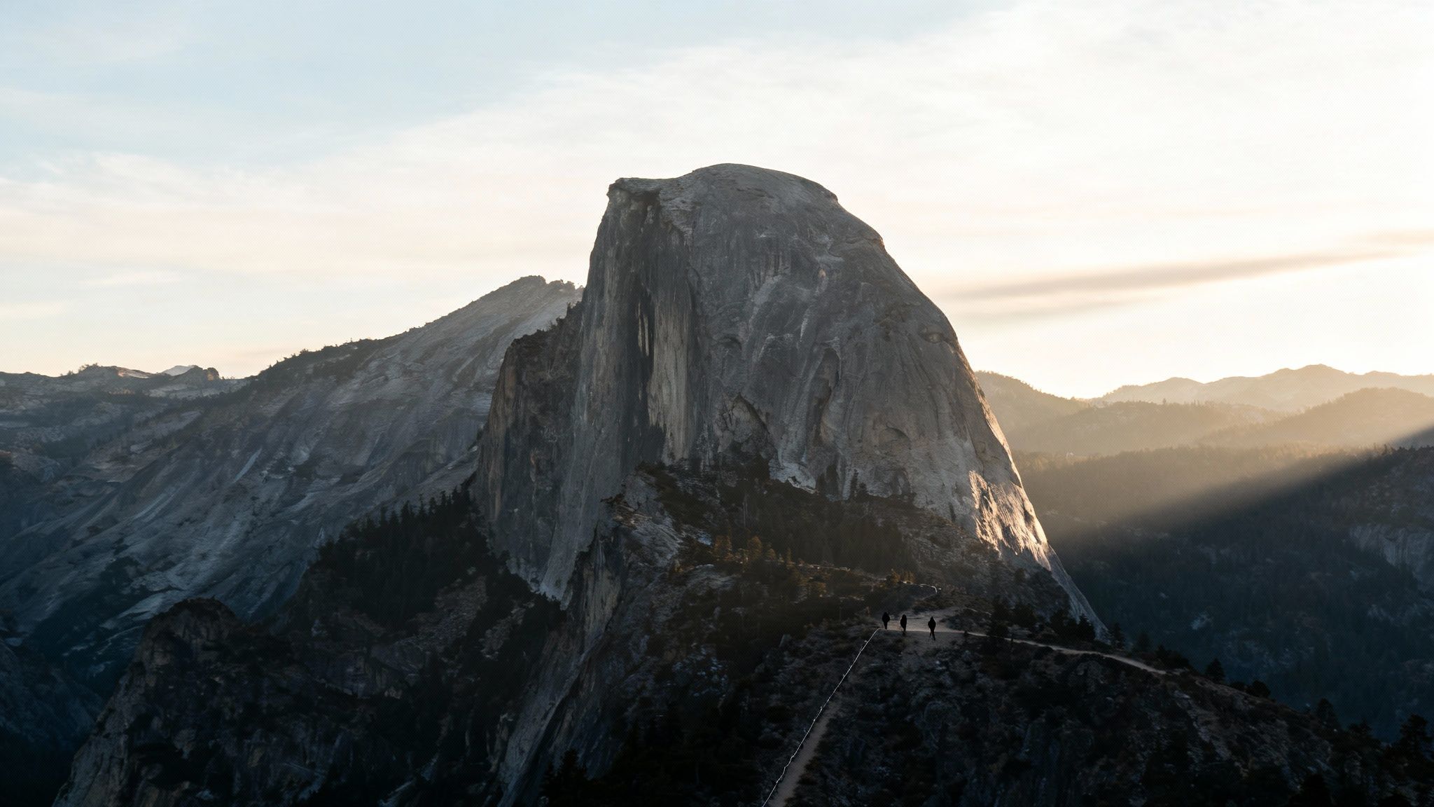
This hike is not just a physical challenge; it's a journey through some of Yosemite’s most famous landscapes, including Vernal and Nevada Falls. The sheer granite dome, famously photographed by Ansel Adams, provides an unforgettable sense of accomplishment, cementing its status as a bucket-list adventure.
Trail Details & Logistics
- Difficulty: Strenuous
- Distance: 14-17 miles (23-27 km) round trip
- Elevation Gain: 4,800 feet (1,463 m)
- Best Season: Late May to early October, when the cables are up.
- Key Tip: A permit is required to ascend the Half Dome cables. These are awarded through a competitive preseason lottery and daily lotteries during the hiking season.
Actionable Advice for Your Trek
Preparation is non-negotiable for this demanding hike. Start before dawn (5-6 AM) to avoid afternoon heat and potential thunderstorms. Carry at least 3-4 liters of water, as the trail is long and exposed. Proper footwear with excellent grip is essential for the granite slabs and the cable section. To celebrate your triumph, memorialize your route with a custom RoutePrinter map. Displaying the trail’s profile and your personal stats, like the grueling 4,800-foot elevation gain, creates a lasting tribute to conquering one of America’s most legendary hikes.
8. Tour du Mont-Blanc, France/Italy/Switzerland
Often hailed as the quintessential alpine trek, the Tour du Mont-Blanc (TMB) is a spectacular 105-mile (170-kilometer) circuit that circumnavigates the Mont Blanc massif. This iconic journey crosses through three countries: France, Italy, and Switzerland, offering a breathtaking panorama of glaciers, lush valleys, and charming mountain villages. It’s one of the best hiking places for those seeking both dramatic scenery and European culture.
The TMB is a hut-to-hut experience, allowing hikers to travel light and enjoy warm meals and comfortable beds in mountain refuges. The trail is exceptionally well-marked and accessible, providing a perfect blend of wilderness challenge and alpine comfort, making it a must-do for long-distance trekkers.
Trail Details & Logistics
- Difficulty: Challenging
- Distance: Approximately 105 miles (170 km)
- Elevation Gain: Around 32,800 ft (10,000 m) of cumulative ascent/descent
- Best Season: Late June to early September.
- Key Tip: While a guide isn't mandatory, booking mountain huts (refuges) is essential. Bookings should be made 3-6 months in advance, especially for the peak season of July and August.
Actionable Advice for Your Trek
Physical preparation is key; focus on endurance training and long-distance hikes with significant elevation changes. Pack versatile layers, as alpine weather can shift from sunny to snowing in a matter of hours, even in summer. Carry enough cash (Euros and Swiss Francs) as many mountain huts do not accept credit cards. After completing this epic three-country circuit, celebrate your achievement. A custom map of your TMB route from RoutePrinter can transform your Strava data into a beautiful piece of art, perfectly capturing every pass and valley of your incredible journey.
9. Kungsleden (King's Trail), Sweden
For those seeking Arctic wilderness and pristine Scandinavian landscapes, the Kungsleden, or King's Trail, is one of the world's best hiking places. This legendary 267-mile (430-kilometer) route winds through the vast Swedish Lapland, a region of soaring mountains, expansive valleys, and powerful rivers. The trail is renowned for its well-maintained network of mountain huts, making it accessible for multi-week expeditions.
The full traverse is an epic undertaking, but the trail is easily broken into more manageable sections, with the northernmost segment from Abisko to Nikkaluokta being the most popular. This flexibility allows hikers of all levels to experience its unique solitude, dramatic scenery, and the magic of the midnight sun or the northern lights.
Trail Details & Logistics
- Difficulty: Varies (Easy to Challenging, depending on section)
- Distance: 267 miles (430 km) total; popular sections are 65 miles (105 km)
- Elevation Gain: Varies significantly by section
- Best Season: Late June to early September for summer hiking; late February to April for ski touring.
- Key Tip: While the trail is well-marked, weather can change rapidly. Always be prepared for cold nights and wet conditions, even in the middle of summer. Booking mountain huts in advance during peak season is highly recommended.
Actionable Advice for Your Trek
Tackle the most iconic section from Abisko to Nikkaluokta for a classic one-week adventure. Pack strong insect repellent for the summer months, as mosquitos can be intense. To train, focus on endurance by completing long-distance walks with the pack you plan to use, ensuring your gear is comfortable and reliable. To commemorate conquering this vast wilderness, capture your Strava track and create a custom RoutePrinter map. It’s a perfect way to display the scale of your journey through one of Europe's last great wilderness areas.
10. Everest Base Camp Trek, Nepal
The Everest Base Camp Trek is a legendary journey that takes adventurers deep into the heart of the Himalayas. This high-altitude trek is more than just a path; it's a pilgrimage to the base of the world's tallest peak, Mount Everest. The route offers unparalleled views of some of the planet's most formidable mountains while immersing trekkers in the rich culture of the Sherpa people.
The trek is a profound experience, combining physical challenge with spiritual and cultural discovery. From the thrilling flight into Lukla to the prayer flags of Tengboche Monastery, this trek rightfully earns its reputation as one of the best hiking places for those seeking true adventure.
Trail Details & Logistics
- Difficulty: Challenging
- Distance: ~80 miles (130 km) round trip
- Elevation Gain: Highest point at Everest Base Camp (17,598 ft / 5,364 m)
- Best Season: Pre-monsoon (March-May) and post-monsoon (September-November).
- Key Tip: Hiring a local guide and porter is highly recommended. It supports the local economy and significantly enhances your safety and enjoyment of the trek.
Actionable Advice for Your Trek
Proper acclimatization is non-negotiable. Plan for rest days in villages like Namche Bazaar and Dingboche to allow your body to adjust to the thinning air. Your mantra should be "climb high, sleep low." Listen to your body and descend if you experience severe symptoms of altitude sickness. After completing this monumental trek, preserve the memory of your achievement. Track your route via Strava and commemorate the journey with a RoutePrinter map. Displaying the trail that took you to the foot of Everest is a powerful reminder of your strength and perseverance.
11. Overland Track, Tasmania, Australia
The Overland Track is Australia’s most celebrated multi-day alpine trek, guiding hikers through the heart of the Tasmanian Wilderness World Heritage Area. This 40-mile (65-kilometer) journey traverses a landscape of rugged mountains, ancient rainforests, and pristine glacial lakes, from the iconic Cradle Mountain to the serene Lake St Clair. It’s a spectacular immersion into one of the planet's last true temperate wildernesses.
The trail is renowned for its well-maintained public hut system and clear paths, making it an accessible yet challenging adventure. Its dramatic scenery and diverse ecosystems, including encounters with unique wildlife, solidify its reputation as one of the best hiking places for those seeking a profound connection with nature.
Trail Details & Logistics
- Difficulty: Moderate
- Distance: 40 miles (65 km) - main track
- Elevation Gain: Varies, with multiple ascents and descents through mountain passes.
- Best Season: The summer months, from November to March, for warmer weather and longer daylight hours.
- Key Tip: During the main season (October to May), you must book a permit and walk from north to south (Cradle Mountain to Lake St Clair). Permits are limited and sell out many months in advance.
Actionable Advice for Your Trek
Tasmania's weather is notoriously unpredictable, even in summer. Pack high-quality waterproof gear and dress in layers to adapt to sudden changes from sunshine to snow. To train, focus on endurance by doing consecutive long-distance walks and incorporate strength training for your legs and core to handle the pack weight over several days. After your trek, preserve the memory of your route through the Tasmanian wilderness. A RoutePrinter map of your Strava data can perfectly capture the track's distinctive path, transforming your achievement into a personal piece of art that celebrates your adventure.
12. West Highland Way, Scotland
The West Highland Way is Scotland's premier long-distance trail and one of the best hiking places for an immersive journey through the heart of the Highlands. This iconic 96-mile (154-kilometer) path stretches from Milngavie, just outside Glasgow, to Fort William at the foot of Ben Nevis. It guides walkers through a stunning and varied landscape, from pastoral lowlands to the remote wilderness of Rannoch Moor and the dramatic valleys of Glencoe.
The route is renowned for its excellent infrastructure, well-marked paths, and the legendary Scottish hospitality found in the villages and pubs along the way. It offers a perfect blend of challenging wilderness trekking and cultural experience, making it accessible yet deeply rewarding for hikers of all levels.
Trail Details & Logistics
- Difficulty: Moderate
- Distance: 96 miles (154 km)
- Elevation Gain: Approximately 12,000 ft (3,657 m) total ascent
- Best Season: April-May or September-October for fewer crowds and midges.
- Key Tip: While wild camping is permitted, booking accommodations like B&Bs and hostels 2-3 months in advance is essential, especially during peak season. Baggage transfer services are widely available and highly recommended.
Actionable Advice for Your Trek
Preparation for the Scottish weather is non-negotiable; pack high-quality waterproofs and layered clothing, as conditions can change in an instant. Most people walk south to north, starting with easier terrain, but consider walking north to south to keep the prevailing wind and sun at your back. Upon completing this classic trek, you can celebrate your 96-mile achievement with a personalized keepsake. A RoutePrinter map of your journey, using your tracked Strava data, is a fantastic way to display the entire route and commemorate your incredible walk through the Highlands.
Top 12 Hiking Destinations Comparison
| Trail | Implementation complexity | Resource requirements | Expected outcomes | Ideal use cases | Key advantages |
|---|---|---|---|---|---|
| The Inca Trail, Peru | High — mandatory permits, guided groups, altitude management | High cost, advance booking (6–12 months), guide, fitness & acclimatization | Sunrise at Machu Picchu, archaeological immersion, varied ecosystems | Short multi-day hikers seeking history and iconic views | Unparalleled Incan heritage and biodiversity |
| Torres del Paine, Chile | High — remote logistics, weather-dependent planning | Moderate–high (weather gear, seasonal lodges/transport) | Dramatic granite peaks, glaciers, lakes, good wildlife sightings | Alpine scenery seekers who tolerate variable weather | Spectacular Patagonia scenery with fewer crowds |
| Appalachian Trail, USA | Variable — from day hikes to multi-month thru-hikes | Moderate (resupply planning, long time commitment for thru-hike) | Long-distance challenge, strong trail community, varied ecosystems | Thru-hikers, section hikers, flexible-duration adventurers | Extensive infrastructure and flexible route options |
| Mont-Blanc Massif, FR/IT/CH | High to technical — possible mountaineering, objective hazards | High (guides for technical sections, refuges, acclimatization) | High-alpine panoramas, mountaineering opportunities | Experienced hikers/mountaineers seeking high-altitude Alpine terrain | Western Europe’s highest peak with strong support systems |
| Milford Track, New Zealand | Moderate — guided, fixed itinerary with organized logistics | High cost (all-inclusive), limited availability, guided services | Pristine fjord and rainforest scenery, waterfalls, wildlife | Hikers wanting an all-inclusive, scenic multi-day walk | Logistics handled by guides; consistently exceptional scenery |
| GR20, Corsica, France | Very high — sustained technical difficulty and navigation | Moderate (refuges, long duration, strong fitness) | Raw, challenging alpine traverse with remote character | Highly fit, experienced alpine trekkers seeking a challenge | Authentic, demanding European alpine experience |
| Half Dome, Yosemite, USA | High — strenuous day hike with exposed cable ascent and permit system | Low–moderate (permit via lottery, day-hike gear, water) | Iconic summit views, intense single-day accomplishment | Fit day-hikers wanting an iconic, technical but non-rope climb | Single-day access to dramatic Yosemite summit views |
| Tour du Mont-Blanc, FR/IT/CH | Moderate to high — multi-day hut-to-hut logistics across borders | Moderate (hut bookings, 7–10 days, cross-border planning) | Classic Alpine circuit with village culture and varied terrain | Hikers wanting a supported hut-to-hut multi-day circuit | Excellent hut infrastructure and varied Alpine scenery |
| Kungsleden (King's Trail), Sweden | Moderate — long distances but good hut network | Moderate (hut bookings, insect protection, seasonal gear) | Arctic wilderness, midnight sun, remote natural immersion | Long-distance hikers seeking Lapland solitude and huts | Pristine Arctic landscapes with established hut system |
| Everest Base Camp Trek, Nepal | High — significant altitude and acclimatization needs | Moderate (teahouses/lodges, permits, guide/porter recommended) | Spectacular Himalayan views and Sherpa cultural exposure | Fit trekkers wanting non-technical high-altitude experience | Direct access to Everest region and strong lodge network |
| Overland Track, Tasmania, Australia | Moderate — booked, guided/hut-based system with regulated access | Moderate–high (operator booking, set dates, hut fees) | Rugged Tasmanian wilderness, lakes, alpine environments | Hikers preferring hut-based multi-day walks with regulation | Reliable hut system and managed wilderness quality |
| West Highland Way, Scotland | Moderate — well-marked, easy logistics but busy seasonally | Low–moderate (accommodation bookings, flexible duration) | Highland glens, lochs, accessible long-distance walk | Multi-day walkers seeking scenic, well-supported routes | Strong infrastructure, varied Highland scenery |
Turn Your Greatest Hikes into Lasting Memories
The journey from trailhead to summit is more than a series of steps; it's a profound experience that tests your limits, expands your horizons, and forever changes your perspective. From the ancient stones of the Inca Trail to the rugged alpine meadows of the Tour du Mont-Blanc, each of the world's best hiking places offers a unique narrative written in sweat, perseverance, and awe. This guide was crafted not just to present a list of destinations but to provide a comprehensive blueprint for turning your dream adventure into a tangible reality.
We've explored the logistical necessities, from securing the coveted permits for the Milford Track to understanding the seasonal nuances of trekking to Everest Base Camp. We’ve broken down complex, multi-week journeys like the Appalachian Trail and Sweden's Kungsleden into manageable segments, empowering you to plan an expedition that aligns perfectly with your timeline and skill level. The core takeaway is simple: with diligent research, thoughtful preparation, and a spirit of adventure, these legendary trails are within your reach. They are not just dots on a map but achievable milestones in your life’s story.
From Digital Data to Enduring Inspiration
After the boots are cleaned and the gear is stored, the memories of your hike live on. Every Strava upload captures more than just metrics like distance and elevation; it holds the story of your effort, the stunning vistas you witnessed, and the personal victories you achieved along the way. Your journey, whether it was conquering the challenging GR20 in Corsica or soaking in the dramatic landscapes of Torres del Paine, is an accomplishment that deserves to be celebrated and remembered.
Transforming this digital footprint into a physical memento serves as a powerful, daily reminder of what you are capable of. It’s one thing to see your route on a screen, but it’s another to have a beautifully designed piece of art that commemorates your achievement. This bridge between the ephemeral digital record and a lasting physical tribute is where the true value of your adventure is solidified.
Your Next Steps on the Path
The true purpose of exploring these best hiking places is to discover something new about the world and, more importantly, about yourself. The discipline required to prepare, the resilience needed to push through challenging terrain, and the quiet moments of reflection on the trail all contribute to significant personal growth. Your adventure doesn't end when you return home; it becomes a part of who you are.
Here are your actionable next steps to continue the journey:
- Select Your Challenge: Revisit the list and identify one or two trails that genuinely resonate with you. Is it the raw, untamed wilderness of Tasmania's Overland Track or the historic pilgrimage of the West Highland Way?
- Begin Your Research: Use our guide as a launchpad. Dive deeper into the specific logistics for your chosen trail. Check official park websites for permit lottery dates, book accommodations or hut systems well in advance, and start creating a detailed gear list.
- Start Training: The greatest trails demand respect. Develop a fitness plan that mimics the conditions you'll face, focusing on elevation gain, endurance, and carrying a weighted pack. Your preparation is the foundation of a successful and enjoyable hike.
- Preserve the Memory: Before you even leave, plan how you will commemorate your journey. Decide which tracking app you'll use and think about how you want to celebrate your accomplishment afterward. Turning your hard-earned route into a lasting piece of art ensures the inspiration endures long after the muscle soreness fades.
Ready to turn your incredible hiking achievement into a work of art? RoutePrinter specializes in transforming your Strava data into a beautiful, minimalist poster that elegantly displays your exact route, name, and key stats. Visit RoutePrinter to create a custom, tangible memory of your adventure and keep the inspiration from the world's best hiking places alive in your home or office.